IMAGES TAKEN NEAR TO
Ffordd Croesawdy, NEWTOWN, SY16 1AE
Introduction
This page details the photographs taken nearby to Ffordd Croesawdy, SY16 1AE by members of the Geograph project.
The Geograph project started in 2005 with the aim of publishing, organising and preserving representative images for every square kilometre of Great Britain, Ireland and the Isle of Man.

There are currently over 7.5m images from over14,400 individuals and you can help contribute to the project by visiting https://www.geograph.org.uk
Image Map
Images are licensed for reuse under creativecommons.org/licenses/by-sa/2.0
Notes
- Clicking on the map will re-center to the selected point.
- The higher the marker number, the further away the image location is from the centre of the postcode.
Image Listing (450 Images Found)
Images are licensed for reuse under creativecommons.org/licenses/by-sa/2.0
Image
Details
Distance
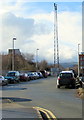
1
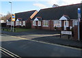
Station Cottages, Ffordd Croesawdy, Newtown
Bungalows on the western approach to Newtown railway station.
Image: © Jaggery
Taken: 1 Feb 2017
0.00 miles
2
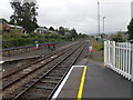
Three tracks SW of Newtown railway station
Viewed from Newtown railway station platform 1. Newtown is on the Cambrian Line, which is mostly single track. The double tracks through and near the station enable trains to pass each other. The short section of track ending in buffers on the left is available for the stabling of wagons etc. The next station ahead is Caersws on the route to Aberystwyth.
Image: © Jaggery
Taken: 23 Jun 2013
0.02 miles
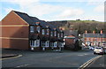
3
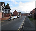
Up Ffordd Croesawdy, Newtown
Ffordd Croesawdy ascends from New Road. Walkers can turn left
at the top of the ascent for a route to Newtown railway station.
Image: © Jaggery
Taken: 1 Feb 2017
0.03 miles
5
Telecoms mast, Ffordd Croesawdy, Newtown
Near Newtown railway station.
Image: © Jaggery
Taken: 1 Feb 2017
0.04 miles
6
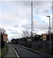
Telecoms mast, Ffordd Croesawdy, Newtown
Near Newtown railway station.
Image: © Jaggery
Taken: 1 Feb 2017
0.04 miles
7
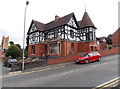
Croesawdy, Newtown
Detached house on the corner of New Road and Ffordd Croesawdy.
The former St David's church http://www.geograph.org.uk/photo/3584592 is in the background.
Image: © Jaggery
Taken: 4 Aug 2013
0.04 miles
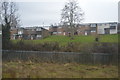
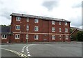
9
West side of Ffordd Croesawdy, Newtown
The houses are alongside the descent towards New Road.
Image: © Jaggery
Taken: 1 Feb 2017
0.05 miles
10
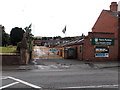
Travis Perkins, Newtown
The Travis Perkins timber and building supplies yard is on the SE side of New Road.
Image: © Jaggery
Taken: 4 Aug 2013
0.06 miles