IMAGES TAKEN NEAR TO
Churchstoke, MONTGOMERY, SY15 6TR
Introduction
This page details the photographs taken nearby to SY15 6TR by members of the Geograph project.
The Geograph project started in 2005 with the aim of publishing, organising and preserving representative images for every square kilometre of Great Britain, Ireland and the Isle of Man.

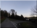
There are currently over 7.5m images from over14,400 individuals and you can help contribute to the project by visiting https://www.geograph.org.uk
Image Map (Loading...)


Getting Data...Please wait
Leaflet Map data © OpenStreetMap
Images are licensed for reuse under creativecommons.org/licenses/by-sa/2.0
Notes
- Clicking on the map will re-center to the selected point.
- The higher the marker number, the further away the image location is from the centre of the postcode.
Image Listing (23 Images Found)
Images are licensed for reuse under creativecommons.org/licenses/by-sa/2.0
Image
Details
Distance
1
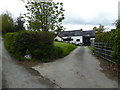
Upper Pantglas farmhouse
Nice old place.
Image: © Jeremy Bolwell
Taken: 6 May 2019
0.01 miles
2
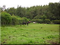
Paddock at Pantglas
Pantglas is just on the English side of the border. This small field containing Welsh cobs and a Shetland pony has the Welsh/English border running behind the hedge on the left-hand side of the photo and the Kerry Ridgeway running behind the hedge at the bottom of the paddock. There's a much larger amount of woodland round here than is apparent from the OS map.
Image: © Liz Clowes
Taken: Unknown
0.04 miles
3
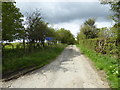
On part of the Kerry Ridgeway / Ffordd Las Ceri
Lovely walking on a morning in early May.
Image: © Jeremy Bolwell
Taken: 6 May 2019
0.06 miles
4
On the lovely Kerry Ridgeway at Pantglas farm
Walk this in Spring and you can't fail to be in a state of euphoria. I walked it in May on a fresh, breezy morning with birdsong everywhere, the sound of lambs on the breeze and a sun breaking through grey clouds at intervals to warm the air. Almost heaven.
Image: © Jeremy Bolwell
Taken: 6 May 2019
0.06 miles
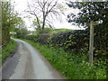
5
Road junction on the Kerry Ridgeway
Forked junction, a rare layout.
Image: © Jeremy Bolwell
Taken: 26 Dec 2016
0.07 miles
6
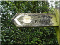
A Kerry Ridgeway / Ffordd Las Ceri fingerpost at Pantglas
The original fingerpost and waymarker disc combination survive here
Image: © Jeremy Bolwell
Taken: 6 May 2019
0.07 miles
7

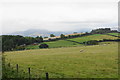
Pond near Pantglas
Although the land is nearly 400 m above sea level, it is all good pasture. The hills of the Welsh Border in the background.
Image: © Oliver Dixon
Taken: 13 Jun 2010
0.07 miles
8
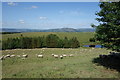
Welsh Sheep In The Meadow
With Corndon Hill on the horizon.
Image: © Peter Jeffery
Taken: 9 Jul 2015
0.10 miles
9
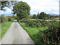
Kerry Ridgeway at Pantglas
The Kerry Ridgeway pictured at pantglas as few metres to the east of where the metalled surface ends.
Image: © Philip Halling
Taken: 12 Sep 2010
0.11 miles
10
Sheep above Pantglas
The line of the Kerry Ridgeway can be seen on the next ridge. Beyond that, a rain shower is hitting the Shropshire Hills.
Image: © Bill Boaden
Taken: 20 Aug 2018
0.11 miles