IMAGES TAKEN NEAR TO
Chirbury Road, MONTGOMERY, SY15 6QQ
Introduction
This page details the photographs taken nearby to Chirbury Road, SY15 6QQ by members of the Geograph project.
The Geograph project started in 2005 with the aim of publishing, organising and preserving representative images for every square kilometre of Great Britain, Ireland and the Isle of Man.

There are currently over 7.5m images from over14,400 individuals and you can help contribute to the project by visiting https://www.geograph.org.uk
Image Map (Loading...)


Getting Data...Please wait
Leaflet Map data © OpenStreetMap
Images are licensed for reuse under creativecommons.org/licenses/by-sa/2.0
Notes
- Clicking on the map will re-center to the selected point.
- The higher the marker number, the further away the image location is from the centre of the postcode.
Image Listing (342 Images Found)
Images are licensed for reuse under creativecommons.org/licenses/by-sa/2.0
Image
Details
Distance
2
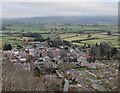
Montgomery viewed from the castle walls
Image: © Mat Fascione
Taken: 18 Dec 2021
0.07 miles
3
B4386 junction
Looking north-east along the road from its junction with Prince's Street.
Image: © Trevor Rickard
Taken: 6 Aug 2007
0.07 miles
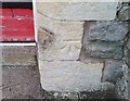
4
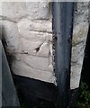
Ordnance Survey Cut Mark
This OS cut mark can be found on the NW angle of The Manor. It marks a point 134.792m above mean sea level.
Image: © Adrian Dust
Taken: 29 Aug 2020
0.07 miles
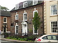
5
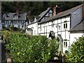
Black and white cottages in Montgomery
Image: © John H Darch
Taken: 21 Sep 2018
0.07 miles
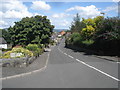
6
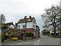
Crossroads at the top of Pool Road, Montgomery
The roads do not cross at right angles; Chirbury Road joins from the left at an acute angle
Image: © David Smith
Taken: 24 Apr 2015
0.08 miles
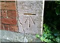
7
Ordnance Survey Cut Mark
This OS cut mark can be found on the south face of the school. It marks a point 160.411m above mean sea level.
Image: © Adrian Dust
Taken: 29 Aug 2020
0.08 miles
9
Ordnance Survey Cut Mark
This OS cut mark can be found on the SE angle of the Methodist Chapel. It marks a point 150.519m above mean sea level.
Image: © Adrian Dust
Taken: 29 Aug 2020
0.09 miles
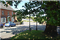
10

Chirbury Road, Montgomery
From the same spot as Image was taken, a view along the road leading out of Montgomery towards Chirbury. The silo tower in the distance is at Image
Image: © Derek Harper
Taken: 2 Jan 2009
0.09 miles