IMAGES TAKEN NEAR TO
Village Green, MONTGOMERY, SY15 6LY
Introduction
This page details the photographs taken nearby to Village Green, SY15 6LY by members of the Geograph project.
The Geograph project started in 2005 with the aim of publishing, organising and preserving representative images for every square kilometre of Great Britain, Ireland and the Isle of Man.

There are currently over 7.5m images from over14,400 individuals and you can help contribute to the project by visiting https://www.geograph.org.uk
Image Map (Loading...)


Getting Data...Please wait
Leaflet Map data © OpenStreetMap
Images are licensed for reuse under creativecommons.org/licenses/by-sa/2.0
Notes
- Clicking on the map will re-center to the selected point.
- The higher the marker number, the further away the image location is from the centre of the postcode.
Image Listing (17 Images Found)
Images are licensed for reuse under creativecommons.org/licenses/by-sa/2.0
Image
Details
Distance
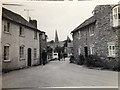
3
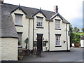
Oak House Llandyssil, Montgomery Circa 1965
Old Coaching Inn
Image: © Wendy Meese
Taken: Unknown
0.03 miles
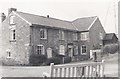
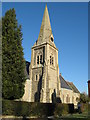
6
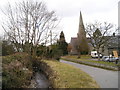
Stream and road
The stream flowing in a sunken channel beside the road. The parish church is beyond.
Image: © Marion Phillips
Taken: 12 Mar 2010
0.05 miles
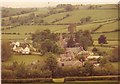
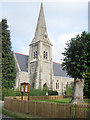
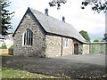
9
St Tyssil Parish Church
A prominent feature in Llandyssil.
Image: © Paul Beaman
Taken: 13 Feb 2008
0.06 miles