IMAGES TAKEN NEAR TO
Abermule, MONTGOMERY, SY15 6JW
Introduction
This page details the photographs taken nearby to SY15 6JW by members of the Geograph project.
The Geograph project started in 2005 with the aim of publishing, organising and preserving representative images for every square kilometre of Great Britain, Ireland and the Isle of Man.

There are currently over 7.5m images from over14,400 individuals and you can help contribute to the project by visiting https://www.geograph.org.uk
Image Map (Loading...)


Getting Data...Please wait
Leaflet Map data © OpenStreetMap
Images are licensed for reuse under creativecommons.org/licenses/by-sa/2.0
Notes
- Clicking on the map will re-center to the selected point.
- The higher the marker number, the further away the image location is from the centre of the postcode.
Image Listing (7 Images Found)
Images are licensed for reuse under creativecommons.org/licenses/by-sa/2.0
Image
Details
Distance
1
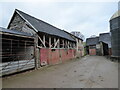
Old barn at Lwynmadoc Hen farm
Proudly displaying farming heritage, old tools and machinery. Great to see.
Image: © Jeremy Bolwell
Taken: 3 Feb 2022
0.03 miles
2
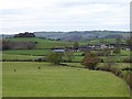
Llwynmadoc Farm
The wooded hill on the left is the same one seen here http://www.geograph.org.uk/photo/611390 .
Image: © Penny Mayes
Taken: 12 Nov 2007
0.05 miles
3
Long concrete drive to and from Lwynmadoc Hen farm
A lengthy traipse, but great views.
Image: © Jeremy Bolwell
Taken: 3 Feb 2022
0.20 miles
4
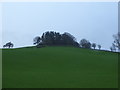
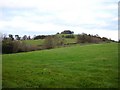
Wooded knoll on the skyline
I wonder what is up there. May visit one day.
Image: © Jeremy Bolwell
Taken: 7 Feb 2016
0.21 miles
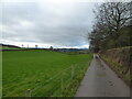
5
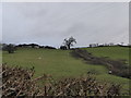
Hill near Llwynmadoc Farm
The road to the farm runs across the photo. The farm itself lies to the right of the hill, concealed by the trees.
Image: © Penny Mayes
Taken: 12 Nov 2007
0.23 miles
6
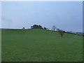
Wooded knoll
I love these sort of landscape features and my eye is always drawn towards them.
Image: © Jeremy Bolwell
Taken: 7 Feb 2016
0.23 miles
7
Hedgeline below Upper Bolbro farm
Hedge-laying in progress.
Image: © Jeremy Bolwell
Taken: 7 Feb 2016
0.24 miles