IMAGES TAKEN NEAR TO
MONTGOMERY, SY15 6JA
Introduction
This page details the photographs taken nearby to SY15 6JA by members of the Geograph project.
The Geograph project started in 2005 with the aim of publishing, organising and preserving representative images for every square kilometre of Great Britain, Ireland and the Isle of Man.

There are currently over 7.5m images from over14,400 individuals and you can help contribute to the project by visiting https://www.geograph.org.uk
Image Map (Loading...)


Getting Data...Please wait
Leaflet Map data © OpenStreetMap
Images are licensed for reuse under creativecommons.org/licenses/by-sa/2.0
Notes
- Clicking on the map will re-center to the selected point.
- The higher the marker number, the further away the image location is from the centre of the postcode.
Image Listing (9 Images Found)
Images are licensed for reuse under creativecommons.org/licenses/by-sa/2.0
Image
Details
Distance
1
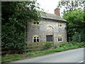
Roadside cottage outside Montgomery
An extremely cute cottage on the roadside.
Image: © Jeremy Bolwell
Taken: 23 Aug 2012
0.01 miles
2
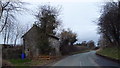
Cottage beside the lane
Nice little place.
Image: © Jeremy Bolwell
Taken: 28 Feb 2015
0.01 miles
4
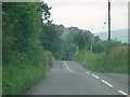
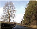
The B4385 Road (Montgomery)
The B4385 road does reach Montgomery, but I took this minutes before we approached the town. By this time, we could already see St. Nicholas church from here, and it looks very nice from here! Above the church on the left is Montgomery Castle, which is covered by a tree in this shot.
Image: © Fabian Musto
Taken: 26 Jul 2019
0.07 miles