IMAGES TAKEN NEAR TO
MONTGOMERY, SY15 6HW
Introduction
This page details the photographs taken nearby to SY15 6HW by members of the Geograph project.
The Geograph project started in 2005 with the aim of publishing, organising and preserving representative images for every square kilometre of Great Britain, Ireland and the Isle of Man.

There are currently over 7.5m images from over14,400 individuals and you can help contribute to the project by visiting https://www.geograph.org.uk
Image Map (21 Images)


Getting Data...Please wait
Leaflet Map data © OpenStreetMap
Images are licensed for reuse under creativecommons.org/licenses/by-sa/2.0
Notes
- Clicking on the map will re-center to the selected point.
- The higher the marker number, the further away the image location is from the centre of the postcode.
Image Listing (21 Images Found)
Images are licensed for reuse under creativecommons.org/licenses/by-sa/2.0
Image
Details
Distance
1
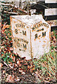
Old Milepost south of Montgomery
Turner Arrow Casting by the UC road, in Montgomery Community (Powys District), The Bungalow, Kerry Road, on verge.
Inscription reads:-
: KERRY / 8-M / NEWTOWN / 11-M / {arrow->} : : WELSHPOOL / {<-arrow} / 8-M :
Grade II listed by Cadw.
Reference Number: 87245 https://cadwpublic-api.azurewebsites.net/reports/listedbuilding/FullReport?lang=&id=87245
Surveyed
Milestone Society National ID: MOT_MTKY00
Image: © Milestone Society
Taken: Unknown
0.02 miles
2
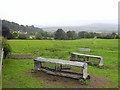
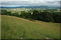
Field with feeders near Montgomery
With a distant glimpse of the town.
Image: © Oliver Dixon
Taken: 13 Jun 2010
0.04 miles
4
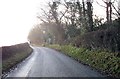
Road with a View.
Looking back towards Montgomery Castle.
Image: © Paul Beaman
Taken: 13 Feb 2008
0.14 miles
5
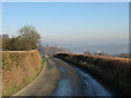
Looking down Town Hill
A glimpse of buildings on the southern edge of Montgomery from beside Image
Image: © Derek Harper
Taken: 2 Jan 2009
0.22 miles
6
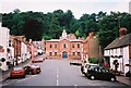
Montgomery Town Hall
A view of Montgomery Town Hall taken during the Foot & Mouth Crisis, everywhere was conspicuously void of tourists.
Image: © Stephen Elwyn RODDICK
Taken: Unknown
0.22 miles
7
View to the east from Town Hill
View to the east from the path ascending Town Hill from near the castle. Much of the landscape in this view is Shropshire and therefore in England, however, Corndon Hill the highest point on the horizon to the right of centre is in Wales, part of a Welsh spur of land which projects into England.
Image: © Philip Halling
Taken: 7 Jul 2010
0.23 miles
8

Trees on Town Hill (5)
Image: © Derek Harper
Taken: 2 Jan 2009
0.23 miles
9

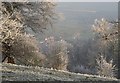
Beech on Town Hill
This frost-covered beech also appears in Image As with Image, Corndon Hill can be seen 9 kilometres away.
Image: © Derek Harper
Taken: 2 Jan 2009
0.23 miles
10

Trees on Town Hill (4)
Hard to stop taking photographs of these frosty trees by the path to Montgomery, especially the magnificent beech on the right. For others, see Image and Image
Image: © Derek Harper
Taken: 2 Jan 2009
0.23 miles