IMAGES TAKEN NEAR TO
Churchstoke, MONTGOMERY, SY15 6HT
Introduction
This page details the photographs taken nearby to SY15 6HT by members of the Geograph project.
The Geograph project started in 2005 with the aim of publishing, organising and preserving representative images for every square kilometre of Great Britain, Ireland and the Isle of Man.

There are currently over 7.5m images from over14,400 individuals and you can help contribute to the project by visiting https://www.geograph.org.uk
Image Map
Images are licensed for reuse under creativecommons.org/licenses/by-sa/2.0
Notes
- Clicking on the map will re-center to the selected point.
- The higher the marker number, the further away the image location is from the centre of the postcode.
Image Listing (9 Images Found)
Images are licensed for reuse under creativecommons.org/licenses/by-sa/2.0
Image
Details
Distance
1
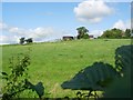
Farm Buildings and field (West Penyllan)
General of field and Farm buildings taken from A489 trunk road. I believe the name to be West Penyllan (52.31'52.62N 0.07'58.09W)
Image: © Tim Marshall
Taken: 13 Sep 2008
0.07 miles
2
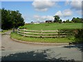
Farm Entrance on A489 near Pentrehayling
View of Farm and Farm Entrance from A489 Trunk road near Pentrehayling (West Penyllan perhaps).
Image: © Tim Marshall
Taken: 13 Sep 2008
0.08 miles
4
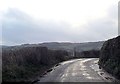
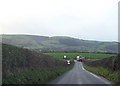
Bend at start of footpath
On Kerry Road south of Cwm Bromley
Image: © John Firth
Taken: 7 Jan 2014
0.16 miles
5
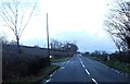
Running into England
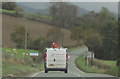
A489 eastbound about to cross the border into England. Shropshire sign post can be seen. East of Sarn
Image: © John Firth
Taken: 31 Oct 2011
0.18 miles
8
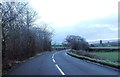
View of A489 Trunk Road
View of A489 trunk road looking east in the direction of Pentreheyling.
Image: © Tim Marshall
Taken: 13 Sep 2008
0.23 miles
9
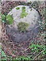
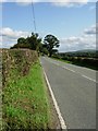
Old Milestone by the A489, south of Cwm Bromley, Kerry Parish
By the A489, in parish of Kerry (Powys District), Cwm Bromley turning, on verge.
Inscription once read:-
: (Bishop's Castle / 7) : : (Newtown / 9) :
Carved bench mark and rivet on top.
Grade II listed by Cadw.
Reference Number 17284: https://cadwpublic-api.azurewebsites.net/reports/listedbuilding/FullReport?lang=&id=17284
Surveyed
Milestone Society National ID: MOT_BINT07
Image: © Milestone Society
Taken: Unknown
0.25 miles