IMAGES TAKEN NEAR TO
Hen-Domen, MONTGOMERY, SY15 6HB
Introduction
This page details the photographs taken nearby to Hen-Domen, SY15 6HB by members of the Geograph project.
The Geograph project started in 2005 with the aim of publishing, organising and preserving representative images for every square kilometre of Great Britain, Ireland and the Isle of Man.

There are currently over 7.5m images from over14,400 individuals and you can help contribute to the project by visiting https://www.geograph.org.uk
Image Map (Loading...)


Getting Data...Please wait
Leaflet Map data © OpenStreetMap
Images are licensed for reuse under creativecommons.org/licenses/by-sa/2.0
Notes
- Clicking on the map will re-center to the selected point.
- The higher the marker number, the further away the image location is from the centre of the postcode.
Image Listing (12 Images Found)
Images are licensed for reuse under creativecommons.org/licenses/by-sa/2.0
Image
Details
Distance
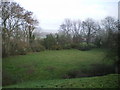
2
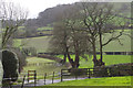
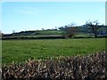
Farmland at Hendomen
Looking down from the hamlet at Hemdonen across very wet fields.
Image: © Stephen McKay
Taken: 9 Feb 2014
0.03 miles
5
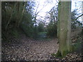
The lower earthworks of Hen Domen castle
A view along the main defensive ditch of the Hen Domen castle mound earthworks. In its heyday, it must have been an impressive construction.
Image: © Richard Law
Taken: 21 Dec 2008
0.06 miles
6
Looking down from the top of the Hen Domen castle mound
Image: © Richard Law
Taken: 21 Dec 2008
0.10 miles
7
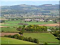
Hen Domen and the Severn valley
View from Ffridd Faldwyn, the Iron Age precursor of Montgomery, towards its Norman successor, the site of the original castle, the wooded mound now known as Hen Domen.
Image: © Mike Parker
Taken: 21 Oct 2021
0.10 miles
8
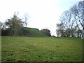
Hen Domen castle mound
Hen Domen is the remains of a Norman 'earth and timber' castle construction, built around 1070. It existed primarily to defend the strategic ford across the Severn at Rhydwhyman, but was eventually replaced and superseded by the castle on the hill above Montgomery.
Image: © Richard Law
Taken: 21 Dec 2008
0.11 miles
10
Siglen Farm
Seen from the road to The Gaer. The second hedge line from the camera marks the course of the railway.
Image: © Penny Mayes
Taken: 11 Dec 2007
0.18 miles