IMAGES TAKEN NEAR TO
Roundton Place, SY15 6FF
Introduction
This page details the photographs taken nearby to Roundton Place, SY15 6FF by members of the Geograph project.
The Geograph project started in 2005 with the aim of publishing, organising and preserving representative images for every square kilometre of Great Britain, Ireland and the Isle of Man.

There are currently over 7.5m images from over14,400 individuals and you can help contribute to the project by visiting https://www.geograph.org.uk
Image Map
Images are licensed for reuse under creativecommons.org/licenses/by-sa/2.0
Notes
- Clicking on the map will re-center to the selected point.
- The higher the marker number, the further away the image location is from the centre of the postcode.
Image Listing (11 Images Found)
Images are licensed for reuse under creativecommons.org/licenses/by-sa/2.0
Image
Details
Distance

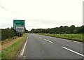
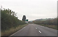
4
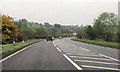
B4386 junction with A483
South of Abermule
Image: © John Firth
Taken: 25 Oct 2012
0.08 miles
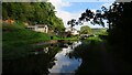
5
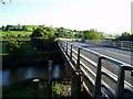
River Severn,Abermule bypass bridge
Built in 1975 carries the A483.Considered to be the thirty third bridge from the source.
Image: © kevin skidmore
Taken: 8 Sep 2004
0.09 miles
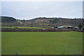
7
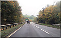
A483 approaching bridge over River Severn
Just north of B4386 junction
Image: © John Firth
Taken: 25 Oct 2012
0.14 miles
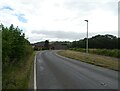
8
A483 at Bryn-y-Maes
Warning sign for B4386 ahead
Image: © John Firth
Taken: 25 Oct 2012
0.16 miles