IMAGES TAKEN NEAR TO
Pool Road, MONTGOMERY, SY15 6EX
Introduction
This page details the photographs taken nearby to Pool Road, SY15 6EX by members of the Geograph project.
The Geograph project started in 2005 with the aim of publishing, organising and preserving representative images for every square kilometre of Great Britain, Ireland and the Isle of Man.

There are currently over 7.5m images from over14,400 individuals and you can help contribute to the project by visiting https://www.geograph.org.uk
Image Map
Images are licensed for reuse under creativecommons.org/licenses/by-sa/2.0
Notes
- Clicking on the map will re-center to the selected point.
- The higher the marker number, the further away the image location is from the centre of the postcode.
Image Listing (3 Images Found)
Images are licensed for reuse under creativecommons.org/licenses/by-sa/2.0
Image
Details
Distance
1
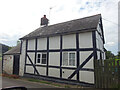
Toll Cottage, Montgomery, B4388
Former Toll House 1.5 km North of the town near the turning for the hamlet of Hendomen.
It served the Montgomery Second District Turnpike Trust in the 19ᵗʰ C.
Milestone Society National ID: POW.MON
Image: © Mr Red
Taken: 24 Aug 2023
0.13 miles
2

A Frosty Day From Stalloe Cottages
Just driving back home but always looking for a 'shot', this just looked right.
Image: © Rod Trevaskus
Taken: 29 Nov 2008
0.22 miles
3
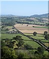
Trefaldwyn Tua'r Trallwng / From Montgomery towards Welshpool
The image was taken from Montgomery Castle, which certainly commanded a strategic location.
Image: © Ceri Thomas
Taken: 8 Aug 2015
0.25 miles