IMAGES TAKEN NEAR TO
Hyssington, MONTGOMERY, SY15 6DZ
Introduction
This page details the photographs taken nearby to SY15 6DZ by members of the Geograph project.
The Geograph project started in 2005 with the aim of publishing, organising and preserving representative images for every square kilometre of Great Britain, Ireland and the Isle of Man.

There are currently over 7.5m images from over14,400 individuals and you can help contribute to the project by visiting https://www.geograph.org.uk
Image Map (Loading...)


Getting Data...Please wait
Leaflet Map data © OpenStreetMap
Images are licensed for reuse under creativecommons.org/licenses/by-sa/2.0
Notes
- Clicking on the map will re-center to the selected point.
- The higher the marker number, the further away the image location is from the centre of the postcode.
Image Listing (16 Images Found)
Images are licensed for reuse under creativecommons.org/licenses/by-sa/2.0
Image
Details
Distance
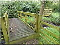
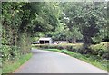
1
Footpath at Llanerch
A new path to follow.
Image: © Jeremy Bolwell
Taken: 22 Apr 2018
0.02 miles
5
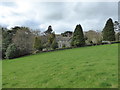
Large country house at Llanerch
Nice place. Wonder what the history is...
Image: © Jeremy Bolwell
Taken: 22 Apr 2018
0.07 miles
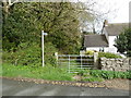
6
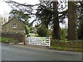
Gateway at The Llanerch
What a nice looking property.
Image: © Jeremy Bolwell
Taken: 22 Apr 2018
0.08 miles
8
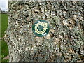
Waymarker on a tree
Part of the Bishop's Castle Ring walks.
Image: © Jeremy Bolwell
Taken: 22 Apr 2018
0.14 miles
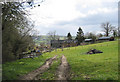
9

Field view near Llanerch
There appear to be ruins in the wooded patch there...
Image: © Jeremy Bolwell
Taken: 22 Apr 2018
0.17 miles
10
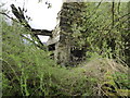
Old chimney breast
Maybe this was a forge or smithy. Or a workshop. Maybe a home?
Image: © Jeremy Bolwell
Taken: 22 Apr 2018
0.17 miles