IMAGES TAKEN NEAR TO
Maes Neuadd, MONTGOMERY, SY15 6DW
Introduction
This page details the photographs taken nearby to Maes Neuadd, SY15 6DW by members of the Geograph project.
The Geograph project started in 2005 with the aim of publishing, organising and preserving representative images for every square kilometre of Great Britain, Ireland and the Isle of Man.

There are currently over 7.5m images from over14,400 individuals and you can help contribute to the project by visiting https://www.geograph.org.uk
Image Map
Images are licensed for reuse under creativecommons.org/licenses/by-sa/2.0
Notes
- Clicking on the map will re-center to the selected point.
- The higher the marker number, the further away the image location is from the centre of the postcode.
Image Listing (70 Images Found)
Images are licensed for reuse under creativecommons.org/licenses/by-sa/2.0
Image
Details
Distance
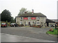
1

The Golden Fish, Churchstoke
A Chinese takeaway.
Image: © Jeremy Bolwell
Taken: 12 Jul 2012
0.06 miles
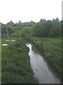
3
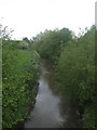
River Camlad at Churchstoke
Flowing north to meet the Severn near Montgomery.
Image: © Jonathan Billinger
Taken: 9 Jan 2008
0.10 miles
4
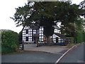
Fir Court House, Churchstoke
An old black and white house, now surrounded by a modern housing estate.
Image: © Jeremy Bolwell
Taken: 18 Sep 2012
0.12 miles
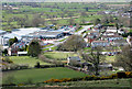
6
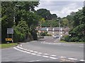
Main road junction at Church Stoke
The A490 from Welshpool comes in from the far right to join the A489 Craven Arms to Newtown road.
Image: © Oliver Dixon
Taken: 13 Jun 2010
0.14 miles
7
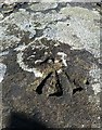
Ordnance Survey Rivet
This OS rivet can be found on the SW parapet of North Bridge. It marks a point 127.293m above mean sea level.
Image: © Adrian Dust
Taken: 29 Aug 2020
0.15 miles
8
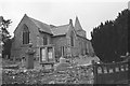
Church Stoke church
St Nicholas' church in Chursh Stoke (meaning: settlement with a church; recorded as "Cirestock" in the 1086 Domesday survey). The church dates back to the 13th century, although only the tower is actually this old, the rest of the church having been rebuilt in the 19th century. There is some interesting civil war history here as in 1646 the Royalist forces stayed overnight in Church Stoke and, when attacked by Parliamentarians, took refuge in the church. The Parliamentarians eventually set fire to the door and forced the Royalists to surrender. The stonework bears the scars of musket fire from other civil war skimishes.
Shot on film using a Pentax K1000 on a date I really can't remember; best guess is late summer 2015.
Image: © John Winder
Taken: Unknown
0.15 miles
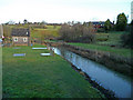
10
River Camlad looking upstream
Downstream of its confluence with the River Caebrita.
Image: © John M
Taken: 23 May 2009
0.17 miles