IMAGES TAKEN NEAR TO
Priest Weston, MONTGOMERY, SY15 6DF
Introduction
This page details the photographs taken nearby to SY15 6DF by members of the Geograph project.
The Geograph project started in 2005 with the aim of publishing, organising and preserving representative images for every square kilometre of Great Britain, Ireland and the Isle of Man.

There are currently over 7.5m images from over14,400 individuals and you can help contribute to the project by visiting https://www.geograph.org.uk
Image Map (Loading...)


Getting Data...Please wait
Leaflet Map data © OpenStreetMap
Images are licensed for reuse under creativecommons.org/licenses/by-sa/2.0
Notes
- Clicking on the map will re-center to the selected point.
- The higher the marker number, the further away the image location is from the centre of the postcode.
Image Listing (17 Images Found)
Images are licensed for reuse under creativecommons.org/licenses/by-sa/2.0
Image
Details
Distance
3
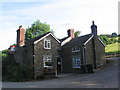
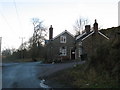
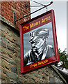
The Old Miners Arms, Priest Weston
An unspoilt pub on the Shropshire-Wales border. By a quirk of local boundaries you have to travel east from here into Wales.
Image: © Jonathan Billinger
Taken: 9 Jan 2008
0.08 miles
4
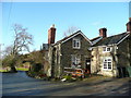
Village Pub
The public house at Priest Weston.
Image: © Paul Beaman
Taken: 9 Jan 2008
0.10 miles
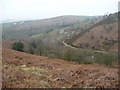
5
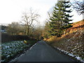
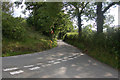
Up Hill And Down Dale
The road down into Priest Weston from White Grit.
Image: © Paul Beaman
Taken: 9 Jan 2008
0.10 miles
6
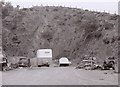
Quarry, Priest Weston
The quarry is cut into Ordovician rocks.
No longer operational it appears to be being used for dumping.
Image: © Richard Sutcliffe
Taken: Unknown
0.16 miles
9
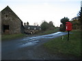
Red Postbox
The village Postbox at Priest Weston.
Image: © Paul Beaman
Taken: 9 Jan 2008
0.17 miles
10
Calcot above Priest Weston
A smallholding or cottage in a hidden valley of the hill country below Lan Fawr and Corndon.
Image: © Jeremy Bolwell
Taken: 27 Mar 2011
0.18 miles