IMAGES TAKEN NEAR TO
Priest Weston, MONTGOMERY, SY15 6BZ
Introduction
This page details the photographs taken nearby to SY15 6BZ by members of the Geograph project.
The Geograph project started in 2005 with the aim of publishing, organising and preserving representative images for every square kilometre of Great Britain, Ireland and the Isle of Man.

There are currently over 7.5m images from over14,400 individuals and you can help contribute to the project by visiting https://www.geograph.org.uk
Image Map (Loading...)


Getting Data...Please wait
Leaflet Map data © OpenStreetMap
Images are licensed for reuse under creativecommons.org/licenses/by-sa/2.0
Notes
- Clicking on the map will re-center to the selected point.
- The higher the marker number, the further away the image location is from the centre of the postcode.
Image Listing (7 Images Found)
Images are licensed for reuse under creativecommons.org/licenses/by-sa/2.0
Image
Details
Distance
1
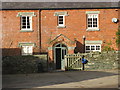
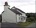
The Farm House
The farm house at Weston House Farm.
Image: © Paul Beaman
Taken: 9 Jan 2008
0.07 miles
2
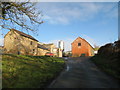
Weston House Farm
Farm buildings at Weston House Farm.
Image: © Paul Beaman
Taken: 9 Jan 2008
0.09 miles
4
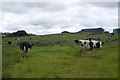
Cattle, Weston House
Holsteins near Priest Weston
Image: © Richard Webb
Taken: 28 Jul 2015
0.12 miles
5
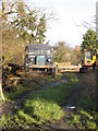
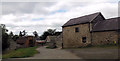
From Days Gone By
A little overgrown nowadays.
Image: © Paul Beaman
Taken: 9 Jan 2008
0.14 miles
7
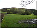
Hills above Middleton
View east from the Middleton to Little Weston road.
Image: © Jonathan Billinger
Taken: 9 Jan 2008
0.22 miles