IMAGES TAKEN NEAR TO
The Bradleys, SHREWSBURY, SY1 4TQ
Introduction
This page details the photographs taken nearby to The Bradleys, SY1 4TQ by members of the Geograph project.
The Geograph project started in 2005 with the aim of publishing, organising and preserving representative images for every square kilometre of Great Britain, Ireland and the Isle of Man.

There are currently over 7.5m images from over14,400 individuals and you can help contribute to the project by visiting https://www.geograph.org.uk
Image Map
Images are licensed for reuse under creativecommons.org/licenses/by-sa/2.0
Notes
- Clicking on the map will re-center to the selected point.
- The higher the marker number, the further away the image location is from the centre of the postcode.
Image Listing (14 Images Found)
Images are licensed for reuse under creativecommons.org/licenses/by-sa/2.0
Image
Details
Distance
2
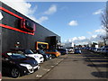
Car dealership on Featherbed Lane, Shrewsbury
A Mini dealership sells its wares.
Image: © Jeremy Bolwell
Taken: 30 Jan 2016
0.13 miles
3
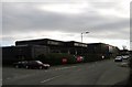
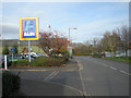
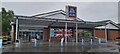
Tesco
This Tesco Store will soon to be closing.
Image: © Mr M Evison
Taken: 11 Feb 2007
0.15 miles
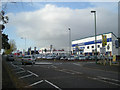
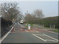
10
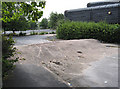
Road block
A cheap way to block access to the old Tesco car park.
Image: © Dave Croker
Taken: 23 Jul 2008
0.22 miles