IMAGES TAKEN NEAR TO
Sundorne Road, SHREWSBURY, SY1 4RG
Introduction
This page details the photographs taken nearby to Sundorne Road, SY1 4RG by members of the Geograph project.
The Geograph project started in 2005 with the aim of publishing, organising and preserving representative images for every square kilometre of Great Britain, Ireland and the Isle of Man.

There are currently over 7.5m images from over14,400 individuals and you can help contribute to the project by visiting https://www.geograph.org.uk
Image Map
Images are licensed for reuse under creativecommons.org/licenses/by-sa/2.0
Notes
- Clicking on the map will re-center to the selected point.
- The higher the marker number, the further away the image location is from the centre of the postcode.
Image Listing (10 Images Found)
Images are licensed for reuse under creativecommons.org/licenses/by-sa/2.0
Image
Details
Distance
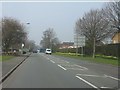
3
Bus stops and shelter on Sundorne Road (B5062)
Image: © JThomas
Taken: 3 Jul 2024
0.10 miles
5
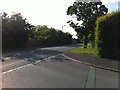
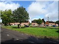
Corner of Alderbury Drive and Featherbed Lane
Image: © Darrin Antrobus
Taken: 10 Jun 2013
0.19 miles
6
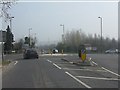
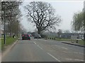
Sundorne Road at Featherbed Lane roundabout
Image: © Peter Whatley
Taken: 23 Mar 2012
0.23 miles
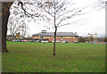
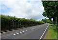
9
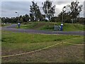
Cycle track at Shrewsbury Sports Village
Image: © TCExplorer
Taken: 14 Sep 2023
0.24 miles
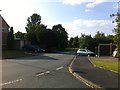
10
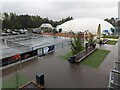
Outdoor tennis courts and air dome at The Shrewsbury Club
On a wet day like the one on which this photo was taken (the wettest day in 50 years in Shrewsbury, apparently, with > 80 mm of rain) the air dome over the tennis courts seems like an extremely good idea!
Image: © TCExplorer
Taken: 8 Sep 2024
0.25 miles