IMAGES TAKEN NEAR TO
Corndon Road, SHREWSBURY, SY1 4LA
Introduction
This page details the photographs taken nearby to Corndon Road, SY1 4LA by members of the Geograph project.
The Geograph project started in 2005 with the aim of publishing, organising and preserving representative images for every square kilometre of Great Britain, Ireland and the Isle of Man.

There are currently over 7.5m images from over14,400 individuals and you can help contribute to the project by visiting https://www.geograph.org.uk
Image Map
Images are licensed for reuse under creativecommons.org/licenses/by-sa/2.0
Notes
- Clicking on the map will re-center to the selected point.
- The higher the marker number, the further away the image location is from the centre of the postcode.
Image Listing (34 Images Found)
Images are licensed for reuse under creativecommons.org/licenses/by-sa/2.0
Image
Details
Distance
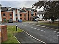
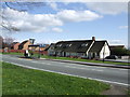
3
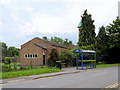
Bus Stop outside Our Lady of Pity Church
Bus stop outside Our Lady of Pity Church, on Meadow Farm Drive.
Image: © David Dixon
Taken: 2 Jun 2019
0.08 miles
5
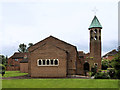
Our Lady of Pity Church, Shrewsbury
Our Lady of Pity Church on Meadow Farm Drive.
Image: © David Dixon
Taken: 2 Jun 2019
0.09 miles
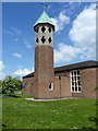
7
Our Lady of Pity Catholic church, Harlescott
Image: © Richard Law
Taken: 17 May 2010
0.09 miles
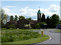
8
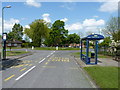
Bus stops and roundabout at the southern end of Meadow Farm Drive
Image: © Richard Law
Taken: 17 May 2010
0.09 miles
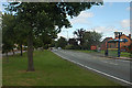
9
Coracle Inn, Sundorne
name celebrates a once common means of travel on the nearby River Severn, Banks's beers.
Image: © al partington
Taken: 25 Apr 2006
0.10 miles