IMAGES TAKEN NEAR TO
Fletcher Place, SHREWSBURY, SY1 4FH
Introduction
This page details the photographs taken nearby to Fletcher Place, SY1 4FH by members of the Geograph project.
The Geograph project started in 2005 with the aim of publishing, organising and preserving representative images for every square kilometre of Great Britain, Ireland and the Isle of Man.

There are currently over 7.5m images from over14,400 individuals and you can help contribute to the project by visiting https://www.geograph.org.uk
Image Map
Images are licensed for reuse under creativecommons.org/licenses/by-sa/2.0
Notes
- Clicking on the map will re-center to the selected point.
- The higher the marker number, the further away the image location is from the centre of the postcode.
Image Listing (7 Images Found)
Images are licensed for reuse under creativecommons.org/licenses/by-sa/2.0
Image
Details
Distance
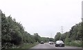
1

Lay-by by A49 east of Battlefield
An unprotected lay-by, used by vehicles travelling northwards or southwards
Image: © David Smith
Taken: 4 Dec 2021
0.06 miles
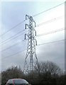
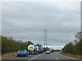
2
Lay-by on A49, Shrewsbury bypass
A line of pylons runs parallel (almost) to the road
Image: © David Smith
Taken: 21 Oct 2011
0.09 miles
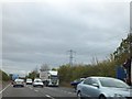
4
Lay-by beside A49 southbound (Shrewsbury bypass)
National Grid power lines cross the road; the line follows the road for several hundred metres.
Image: © David Smith
Taken: 21 Oct 2011
0.16 miles
5
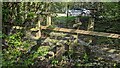
Footpath stile
This section of the footpath now sites between a housing estate and the busy A49 road, which you have to cross to continue.
Image: © TCExplorer
Taken: 18 Apr 2023
0.23 miles
6

Footpath stile
This section of the footpath now sites between an electricity pylon and the busy A49 road, which you have to cross to continue.
Image: © TCExplorer
Taken: 18 Apr 2023
0.24 miles