IMAGES TAKEN NEAR TO
Delune Crescent, MALPAS, SY14 8FB
Introduction
This page details the photographs taken nearby to Delune Crescent, SY14 8FB by members of the Geograph project.
The Geograph project started in 2005 with the aim of publishing, organising and preserving representative images for every square kilometre of Great Britain, Ireland and the Isle of Man.

There are currently over 7.5m images from over14,400 individuals and you can help contribute to the project by visiting https://www.geograph.org.uk
Image Map
Images are licensed for reuse under creativecommons.org/licenses/by-sa/2.0
Notes
- Clicking on the map will re-center to the selected point.
- The higher the marker number, the further away the image location is from the centre of the postcode.
Image Listing (8 Images Found)
Images are licensed for reuse under creativecommons.org/licenses/by-sa/2.0
Image
Details
Distance
1
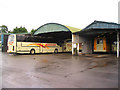
Meredith's Coaches, Malpas
Website at http://www.meredithscoaches.co.uk/
Image: © Peter Craine
Taken: 3 Sep 2006
0.08 miles
2
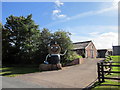
Straw Man at Broselake Farm
A straw man (possibly related to Bertie Bassett) gives a friendly wave to passers by at Broselake Farm on Greenway Lane, Malpas.
Image: © Jeff Buck
Taken: 28 Aug 2014
0.12 miles
5
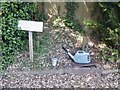
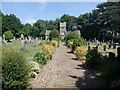
Tap, Malpas Cemetery
Cemeteries and church yards are often a source of water.
Image: © Richard Webb
Taken: 15 Jun 2021
0.22 miles
6
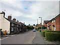
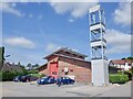
Well Street, Malpas
Looking west along Well Street towards Old Hall Street. St Oswald's Church can be seen in the middle distance.
Image: © Jeff Buck
Taken: 28 Aug 2014
0.22 miles