IMAGES TAKEN NEAR TO
Chester Road, MALPAS, SY14 8DY
Introduction
This page details the photographs taken nearby to Chester Road, SY14 8DY by members of the Geograph project.
The Geograph project started in 2005 with the aim of publishing, organising and preserving representative images for every square kilometre of Great Britain, Ireland and the Isle of Man.

There are currently over 7.5m images from over14,400 individuals and you can help contribute to the project by visiting https://www.geograph.org.uk
Image Map
Images are licensed for reuse under creativecommons.org/licenses/by-sa/2.0
Notes
- Clicking on the map will re-center to the selected point.
- The higher the marker number, the further away the image location is from the centre of the postcode.
Image Listing (11 Images Found)
Images are licensed for reuse under creativecommons.org/licenses/by-sa/2.0
Image
Details
Distance
1
A41 at the footpath (and cow) crossing
The traffic light on the right is activated when cows need to cross this busy primary route!
Image: © Peter Whatley
Taken: 23 Mar 2012
0.12 miles
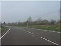
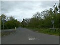
2
A41 towards Chester
Looking north west - the road now bypasses No Mans Heath.
Image: © JThomas
Taken: 4 May 2019
0.17 miles
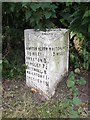
3
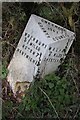
Old Milepost by Bickley Lane, No Man's Heath
Cast iron post by the UC road, in parish of Bickley (Chester District), No Man's Heath, West of the A41, under hedge near 30 sign, on North side of road. Cast iron CCC1901, erected by the County Council in the 20th century.
Inscription reads:-
: WRENBURY / 5¾ MILES / ASTON 7¼ / NANTWICH 11 : : CHESHIRE / 1901 / COUNTY COUNCIL : : MALPAS / 2 MILES / CHESTER 15 :
Maker:-
: W H SMITH & CO / MAKERS / WHITCHURCH :
Milestone Society National ID: CH_NWMP11
Image: © C Minto
Taken: 27 Jul 2003
0.17 miles
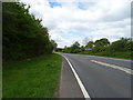
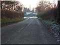
5
The Old Coach Road, north of No Man's Heath
Image: © David Smith
Taken: 29 Apr 2024
0.19 miles
6

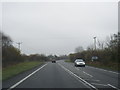
A41 at the turning for Robberhill
The oncoming car's overtaking manoeuvre is perhaps best described as unwise.
Image: © Peter Whatley
Taken: 23 Mar 2012
0.19 miles
7
Old Milepost by the former A41 in No Man's Heath
Cast iron post by the UC road (was A41), in parish of MACEFEN (CHESTER District), No Man's Heath, on the verge. Cast iron CCC1898, erected by the County Council in the 19th century.
Inscription reads:-
: HAMPTON HEATH / 1½ MILES / BROXTON 5 / HANDLEY 7¼ / TATTENHALL 8 / WAVERTON 11 / CHESTER 15 : : CHESHIRE / 1898 / COUNTY COUNCIL : : WHITCHURCH / 5 MILES :
Maker:-
: W H SMITH & CO / MAKER / WHITCHURCH :
Milestone Society National ID: CH_WCWT05.
Image: © J Haynes
Taken: 4 Jan 2013
0.20 miles
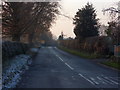
8
Down the Road
Minor road leading from Hampton Green meets with the A41.
Image: © J Scott
Taken: 29 Nov 2010
0.20 miles
9
No Man's Road
Minor road off the A41 leading to No Man's Heath.
Image: © J Scott
Taken: 29 Nov 2010
0.22 miles
10
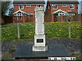
The Celia Fiennes Waymark
The Celia Fiennes Waymark, which has become known locally as 'The Monument', was unveiled on a very cold, wet and windy day in December 1998. It was commissioned to commemorate the 300th anniversary of the 'Great Journey' undertaken by a remarkable lady who, in the reign of William and Mary, travelled throughout Great Britain, riding side saddle and with only the minimum of company.
Part of her route in 1698 brought her down the Old Coach Road to join the medieval road from Chester, which later became the A41, on her way to stay the night in Whitchurch. During all of her travellings, this was the only time in which she encountered highwaymen! Two rather shady characters followed her down the road from Tarporley, through Beeston, Bulkeley and Hampton Post and then into No Mans Heath itself. Fortunately it was market day in Whitchurch and, as Celia approached the town, the highwaymen backed off, deterred by the increasing crowd of market-goers. Look closely at the monument and you will see carvings of Celia herself, her horse, the highwaymen and the market people.
Image: © Graham Flint
Taken: 6 May 2006
0.24 miles