IMAGES TAKEN NEAR TO
Bawbrook, MALPAS, SY14 8DW
Introduction
This page details the photographs taken nearby to Bawbrook, SY14 8DW by members of the Geograph project.
The Geograph project started in 2005 with the aim of publishing, organising and preserving representative images for every square kilometre of Great Britain, Ireland and the Isle of Man.

There are currently over 7.5m images from over14,400 individuals and you can help contribute to the project by visiting https://www.geograph.org.uk
Image Map (Loading...)


Getting Data...Please wait
Leaflet Map data © OpenStreetMap
Images are licensed for reuse under creativecommons.org/licenses/by-sa/2.0
Notes
- Clicking on the map will re-center to the selected point.
- The higher the marker number, the further away the image location is from the centre of the postcode.
Image Listing (5 Images Found)
Images are licensed for reuse under creativecommons.org/licenses/by-sa/2.0
Image
Details
Distance
1
Disused railway bridge, Bawbrook
Former railway bridge on the busy minor road between No Man's Heath and Malpas. The railway is disused (see Image)
Image: © Espresso Addict
Taken: 28 Jan 2007
0.03 miles
2
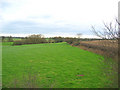
Line of disused railway at Bawbrook
The boundary between pasture and arable fields marks the route of a dismantled railway line to Whitchurch. Little trace is now visible on the ground here, but further south, railway embankments remain (see Image). View from by the former railway bridge on the lane between Malpas and No Man's Heath (see Image)
Image: © Espresso Addict
Taken: 28 Jan 2007
0.08 miles
3
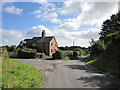
Lane Junction at Bawbrook
The junction of Well Street (ahead) and Ebnal Lane (on the left) at Bawbrook.
Image: © Jeff Buck
Taken: 28 Aug 2014
0.11 miles
4
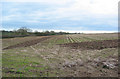
Winter stubble, near Bawbrook
This large gently sloping arable field was an exception in an area largely used for pasture. The boundary on the left is the line of a disused railway; see Image
Image: © Espresso Addict
Taken: 28 Jan 2007
0.15 miles
5
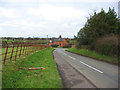
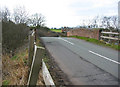
Minor road near Bawbrook
This busy minor road between Malpas and No Man's Heath is one of the few local unclassified roads with two carriageways. The rusty railings lining the road are typical of this part of Cheshire. The red-brick cottage is on the junction of the lane to Ebnal
Image: © Espresso Addict
Taken: 28 Jan 2007
0.16 miles