IMAGES TAKEN NEAR TO
Hampton Crescent, MALPAS, SY14 8DS
Introduction
This page details the photographs taken nearby to Hampton Crescent, SY14 8DS by members of the Geograph project.
The Geograph project started in 2005 with the aim of publishing, organising and preserving representative images for every square kilometre of Great Britain, Ireland and the Isle of Man.

There are currently over 7.5m images from over14,400 individuals and you can help contribute to the project by visiting https://www.geograph.org.uk
Image Map
Images are licensed for reuse under creativecommons.org/licenses/by-sa/2.0
Notes
- Clicking on the map will re-center to the selected point.
- The higher the marker number, the further away the image location is from the centre of the postcode.
Image Listing (5 Images Found)
Images are licensed for reuse under creativecommons.org/licenses/by-sa/2.0
Image
Details
Distance
1
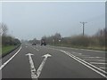
A41 at the turning for Robberhill
The oncoming car's overtaking manoeuvre is perhaps best described as unwise.
Image: © Peter Whatley
Taken: 23 Mar 2012
0.21 miles
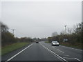
3
A41 at the footpath (and cow) crossing
The traffic light on the right is activated when cows need to cross this busy primary route!
Image: © Peter Whatley
Taken: 23 Mar 2012
0.23 miles
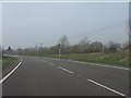
4
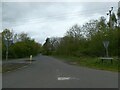
Down the Road
Minor road leading from Hampton Green meets with the A41.
Image: © J Scott
Taken: 29 Nov 2010
0.23 miles
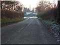
5
The Old Coach Road, north of No Man's Heath
Image: © David Smith
Taken: 29 Apr 2024
0.24 miles