IMAGES TAKEN NEAR TO
Bulkeley, MALPAS, SY14 8BX
Introduction
This page details the photographs taken nearby to SY14 8BX by members of the Geograph project.
The Geograph project started in 2005 with the aim of publishing, organising and preserving representative images for every square kilometre of Great Britain, Ireland and the Isle of Man.

There are currently over 7.5m images from over14,400 individuals and you can help contribute to the project by visiting https://www.geograph.org.uk
Image Map (Loading...)


Getting Data...Please wait
Leaflet Map data © OpenStreetMap
Images are licensed for reuse under creativecommons.org/licenses/by-sa/2.0
Notes
- Clicking on the map will re-center to the selected point.
- The higher the marker number, the further away the image location is from the centre of the postcode.
Image Listing (32 Images Found)
Images are licensed for reuse under creativecommons.org/licenses/by-sa/2.0
Image
Details
Distance
1
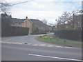
Modern Bulkeley
Modern housing development in Bulkeley village.
Image: © Dennis Turner
Taken: 15 Apr 2006
0.03 miles
3
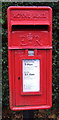
Close up, Elizabeth II postbox on Cholmondeley Lane, Bulkeley
Postbox No. SY14 637.
See Image] for wider view.
Image: © JThomas
Taken: 3 Dec 2016
0.11 miles
4
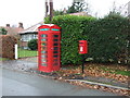
Elizabeth II postbox and telephone box on Cholmondeley Lane, Bulkeley
Phonebox no longer in use as such - now houses a defibrillator.
Postbox No. SY14 637.
See Image] for close up.
Image: © JThomas
Taken: 3 Dec 2016
0.11 miles
5
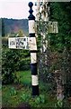
Direction Sign - Signpost by the A534, Wrexham Road, Bulkeley Cross
Pawn finial - 3 arms; CCC plain post by the A534, in parish of Bulkeley (Crewe and Nantwich District), Wrexham Road junction with Mill Lane and Cholmondeley Lane at Bulkeley Cross.
Surveyed
Milestone Society National ID: CH_SJ5354
Image: © Milestone Society
Taken: Unknown
0.11 miles
6
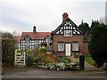
The Gables, Bulkeley
The Gables, a half-timbered style semi-detached house on Cholmondeley Road, Bulkeley.
Image: © Jeff Buck
Taken: 10 Dec 2013
0.12 miles
8
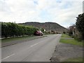
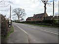
House on Mill Lane, Bulkeley
One of the older houses on Mill Lane on the northern edge of Bulkeley. The Peckforton Hills are in the background
Image: © Espresso Addict
Taken: 24 May 2008
0.12 miles
9
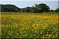
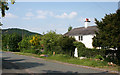
Buttercups galore!
Undulating field of pasture south of Bulkeley village, the predominant agricultural usage in this square. Bulkeley Hill (left) and the Peckforton Hills are in the distance. View from the public footpath running westwards from Cholmondeley Lane
Image: © Espresso Addict
Taken: 24 May 2008
0.12 miles
10
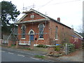
Former Bulkeley Methodist Church
Bulkeley Methodist Church is dated 1861 and was originally called the Jubilee Primitive Methodist Chapel.
The property was sold at auction in May 2016 with planning permission for conversion into a single dwelling.
It is Grade II listed.
Image: © JThomas
Taken: 3 Dec 2016
0.13 miles