IMAGES TAKEN NEAR TO
Egerton, MALPAS, SY14 8AN
Introduction
This page details the photographs taken nearby to SY14 8AN by members of the Geograph project.
The Geograph project started in 2005 with the aim of publishing, organising and preserving representative images for every square kilometre of Great Britain, Ireland and the Isle of Man.

There are currently over 7.5m images from over14,400 individuals and you can help contribute to the project by visiting https://www.geograph.org.uk
Image Map
Images are licensed for reuse under creativecommons.org/licenses/by-sa/2.0
Notes
- Clicking on the map will re-center to the selected point.
- The higher the marker number, the further away the image location is from the centre of the postcode.
Image Listing (7 Images Found)
Images are licensed for reuse under creativecommons.org/licenses/by-sa/2.0
Image
Details
Distance
1
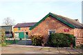
Yew Tree Organic Farm, Egerton Green
Yew Tree Organic Farm on Bickerton Road at Egerton Green.
Image: © Jeff Buck
Taken: 30 Nov 2013
0.03 miles
3
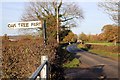
Bickerton Road near Egerton Green
Bickerton Road heading north past Oak Tree Farm.
Image: © Jeff Buck
Taken: 30 Nov 2013
0.11 miles
4
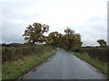
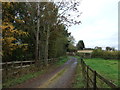
National Cycle Route 45
Looking south east on Bickerton Road.
Image: © JThomas
Taken: 12 Nov 2016
0.11 miles
5
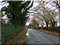
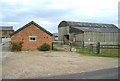
Bickerton Road near Ivy Farm
Looking south east on National Cycle Route 45.
Image: © JThomas
Taken: 12 Nov 2016
0.21 miles