IMAGES TAKEN NEAR TO
Cholmondeley, MALPAS, SY14 8AL
Introduction
This page details the photographs taken nearby to SY14 8AL by members of the Geograph project.
The Geograph project started in 2005 with the aim of publishing, organising and preserving representative images for every square kilometre of Great Britain, Ireland and the Isle of Man.

There are currently over 7.5m images from over14,400 individuals and you can help contribute to the project by visiting https://www.geograph.org.uk
Image Map (5 Images)


Getting Data...Please wait
Leaflet Map data © OpenStreetMap
Images are licensed for reuse under creativecommons.org/licenses/by-sa/2.0
Notes
- Clicking on the map will re-center to the selected point.
- The higher the marker number, the further away the image location is from the centre of the postcode.
Image Listing (5 Images Found)
Images are licensed for reuse under creativecommons.org/licenses/by-sa/2.0
Image
Details
Distance
1
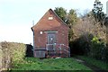
BT Telephone Exchange at Egerton Green
BT Telephone Exchange on Bickerton Road at Egerton Green.
Thanks to David Hillas for the following info.
Hi Jeff
I was interested to see your photo of the TE at Egerton Green. It used to take the name Cholmondeley after the nearby Castle. This TE dates from the GPO era, ie before 1969 and can be recognised by the BT warning notice and the ventilation louvre(s) which keeps it air-cooled. They can get hot inside due to the digital equipment. This TE is in the Tarporley group with numbers beginning with 72, and its postcode is SY14 8AL.
Regards
David
Image: © Jeff Buck
Taken: 30 Nov 2013
0.02 miles
3
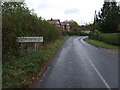
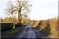
Entering Cholmondeley
On National Cycle Route 45.
Image: © JThomas
Taken: 12 Nov 2016
0.09 miles