IMAGES TAKEN NEAR TO
Willington, MALPAS, SY14 7LZ
Introduction
This page details the photographs taken nearby to SY14 7LZ by members of the Geograph project.
The Geograph project started in 2005 with the aim of publishing, organising and preserving representative images for every square kilometre of Great Britain, Ireland and the Isle of Man.

There are currently over 7.5m images from over14,400 individuals and you can help contribute to the project by visiting https://www.geograph.org.uk
Image Map (Loading...)


Getting Data...Please wait
Leaflet Map data © OpenStreetMap
Images are licensed for reuse under creativecommons.org/licenses/by-sa/2.0
Notes
- Clicking on the map will re-center to the selected point.
- The higher the marker number, the further away the image location is from the centre of the postcode.
Image Listing (4 Images Found)
Images are licensed for reuse under creativecommons.org/licenses/by-sa/2.0
Image
Details
Distance
1
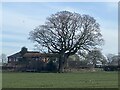
Waiting for spring
An oak tree in winter plumage.
Image: © John H Darch
Taken: 1 Mar 2022
0.05 miles
3
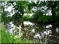
Pond at Lane End Farm
North of the A525, about half way between Bangor on Dee and Whitchurch
Image: © Eirian Evans
Taken: 5 Jun 2006
0.22 miles
