IMAGES TAKEN NEAR TO
Willington, MALPAS, SY14 7LX
Introduction
This page details the photographs taken nearby to SY14 7LX by members of the Geograph project.
The Geograph project started in 2005 with the aim of publishing, organising and preserving representative images for every square kilometre of Great Britain, Ireland and the Isle of Man.

There are currently over 7.5m images from over14,400 individuals and you can help contribute to the project by visiting https://www.geograph.org.uk
Image Map (Loading...)


Getting Data...Please wait
Leaflet Map data © OpenStreetMap
Images are licensed for reuse under creativecommons.org/licenses/by-sa/2.0
Notes
- Clicking on the map will re-center to the selected point.
- The higher the marker number, the further away the image location is from the centre of the postcode.
Image Listing (7 Images Found)
Images are licensed for reuse under creativecommons.org/licenses/by-sa/2.0
Image
Details
Distance
2
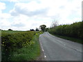
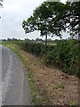
Buck Bend
Country lane leading to the A525 near Horseman's Green.
Image: © J Scott
Taken: 28 Jul 2011
0.06 miles
3
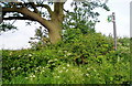
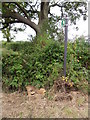
Footpath to Buck Farm
The Right to Roamers have not been ensuring that this footpath is kept open!
Image: © Eirian Evans
Taken: 5 Jun 2006
0.08 miles
4
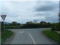
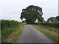
Buck Path
Footpath entrance leading across field to Buck Farm alongside the A525.
Image: © J Scott
Taken: 28 Jul 2011
0.10 miles
6
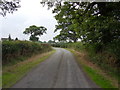
Plassey Road
Country lane leading to Plassey from the A525, near Horseman's Green.
Image: © J Scott
Taken: 28 Jul 2011
0.12 miles