IMAGES TAKEN NEAR TO
Kidnal, MALPAS, SY14 7DJ
Introduction
This page details the photographs taken nearby to SY14 7DJ by members of the Geograph project.
The Geograph project started in 2005 with the aim of publishing, organising and preserving representative images for every square kilometre of Great Britain, Ireland and the Isle of Man.

There are currently over 7.5m images from over14,400 individuals and you can help contribute to the project by visiting https://www.geograph.org.uk
Image Map
Images are licensed for reuse under creativecommons.org/licenses/by-sa/2.0
Notes
- Clicking on the map will re-center to the selected point.
- The higher the marker number, the further away the image location is from the centre of the postcode.
Image Listing (11 Images Found)
Images are licensed for reuse under creativecommons.org/licenses/by-sa/2.0
Image
Details
Distance
1
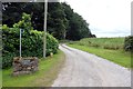
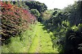
Footpath to Overton Scar
Footpath leading to Overton Scar, a sandstone outcrop overlooking Whitewood Lane.
Image: © Jeff Buck
Taken: 3 Sep 2013
0.07 miles
2
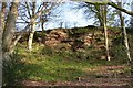
Overton Scar
Wooded sandstone outcrop, quite impressive in places.
Image: © Dave Dunford
Taken: 5 Apr 2009
0.13 miles

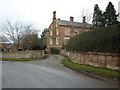
4
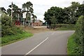
Lane junction at Kidnal
The junction of Whitewood Lane and Tilston Road. The farm ahead is Kidnal House Farm, a dairy farm.
Image: © Jeff Buck
Taken: 3 Sep 2013
0.16 miles
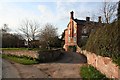
6
Kidnal House Farm
Kidnal House Farm is owned by A C Robinson & Son, producers of organic milk.
Image: © Jeff Buck
Taken: 3 Sep 2013
0.17 miles
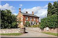
7
Kidnal House
Fine brick-built farmhouse at Kidnal.
Image: © Dave Dunford
Taken: 5 Apr 2009
0.18 miles
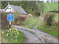
10
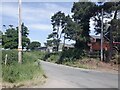
Footpath to Kidnal Hill
Footpath leading to Gam's Wood and Kidnal Hill near Tilston Road, Kidnal.
Image: © Jeff Buck
Taken: 3 Sep 2013
0.23 miles