IMAGES TAKEN NEAR TO
Shocklach, MALPAS, SY14 7BT
Introduction
This page details the photographs taken nearby to SY14 7BT by members of the Geograph project.
The Geograph project started in 2005 with the aim of publishing, organising and preserving representative images for every square kilometre of Great Britain, Ireland and the Isle of Man.

There are currently over 7.5m images from over14,400 individuals and you can help contribute to the project by visiting https://www.geograph.org.uk
Image Map (5 Images)


Getting Data...Please wait
Leaflet Map data © OpenStreetMap
Images are licensed for reuse under creativecommons.org/licenses/by-sa/2.0
Notes
- Clicking on the map will re-center to the selected point.
- The higher the marker number, the further away the image location is from the centre of the postcode.
Image Listing (5 Images Found)
Images are licensed for reuse under creativecommons.org/licenses/by-sa/2.0
Image
Details
Distance
1
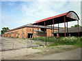
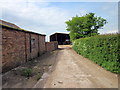
Farm Buildings at Shocklach Hall
Shocklach Hall farm buildings on Shocklach Hall Lane.
Image: © Jeff Buck
Taken: 15 May 2014
0.02 miles
2
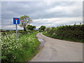
Shocklach Hall Lane
At the junction of Flennen's Brook Lane.
Image: © Jeff Buck
Taken: 15 May 2014
0.13 miles
3
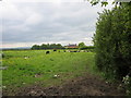
Footpath to Shocklach Green
The building ahead is Shocklach Hall. The path veers to the right skirting around the property.
Image: © Jeff Buck
Taken: 15 May 2014
0.14 miles
4
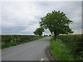
Flennen's Brook Lane
Flennen's Brook Lane heading south from the junction with Shocklach Hall Lane.
Image: © Jeff Buck
Taken: 15 May 2014
0.14 miles
5
Dogkennel Farm, Shocklach
The footpath continues through Dogkennel Farm and towards the River Dee.
Image: © Jeff Buck
Taken: 15 May 2014
0.17 miles