IMAGES TAKEN NEAR TO
Shocklach Road, MALPAS, SY14 7AZ
Introduction
This page details the photographs taken nearby to Shocklach Road, SY14 7AZ by members of the Geograph project.
The Geograph project started in 2005 with the aim of publishing, organising and preserving representative images for every square kilometre of Great Britain, Ireland and the Isle of Man.

There are currently over 7.5m images from over14,400 individuals and you can help contribute to the project by visiting https://www.geograph.org.uk
Image Map
Images are licensed for reuse under creativecommons.org/licenses/by-sa/2.0
Notes
- Clicking on the map will re-center to the selected point.
- The higher the marker number, the further away the image location is from the centre of the postcode.
Image Listing (5 Images Found)
Images are licensed for reuse under creativecommons.org/licenses/by-sa/2.0
Image
Details
Distance
1
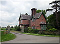
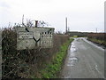
Middle Lodge, Broughton Park
Middle Lodge at the entrance to Broughton Park (private road) on the B5069 (Wrexham Road).
Image: © Jeff Buck
Taken: 15 May 2014
0.13 miles
4
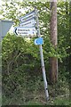
All roads lead to............?
This sign just inside the National Wales/England boundary, but sporting a Cheshire County Sign also.
Image: © Geoff Evans
Taken: 30 Apr 2007
0.22 miles
5
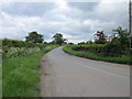
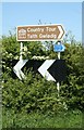
Pre-Worboys road sign near Worthenbury
This pre-Worboys road sign is on the B5069 heading south towards Worthenbury.
Image: © John S Turner
Taken: 17 Jan 2009
0.22 miles