IMAGES TAKEN NEAR TO
Greaves Lane, MALPAS, SY14 7AS
Introduction
This page details the photographs taken nearby to Greaves Lane, SY14 7AS by members of the Geograph project.
The Geograph project started in 2005 with the aim of publishing, organising and preserving representative images for every square kilometre of Great Britain, Ireland and the Isle of Man.

There are currently over 7.5m images from over14,400 individuals and you can help contribute to the project by visiting https://www.geograph.org.uk
Image Map (Loading...)


Getting Data...Please wait
Leaflet Map data © OpenStreetMap
Images are licensed for reuse under creativecommons.org/licenses/by-sa/2.0
Notes
- Clicking on the map will re-center to the selected point.
- The higher the marker number, the further away the image location is from the centre of the postcode.
Image Listing (9 Images Found)
Images are licensed for reuse under creativecommons.org/licenses/by-sa/2.0
Image
Details
Distance
1
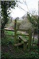
Lower Threapwood - footpath Threapwood 6
Stile on footpath Threapwood 6, looking north. Cross the stile and turn left for the disused windmill; the field beyond the stile drops steeply to a stream.
Image: © Dave Dunford
Taken: 5 Apr 2009
0.05 miles
2
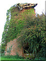
Disused windmill at Threapwood
The large metal cog at the top looks as if it's going to fall at any moment...
Image: © Peter Craine
Taken: 3 Sep 2006
0.08 miles
3
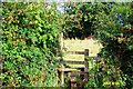
Lower Threapwood - footpath Threapwood 19
View on bearing of 70 deg. Threapwood is the 'last village in Cheshire' - in the SW of the county, just on the Welsh border. A traditional farming community, tucked away from all major roads. A deep wooded clough, whose rim is seen in the background of the image, divides the village into 'Lower' and 'Higher' Threapwood. Footpath 19 leads from the bus depot at the end of Greaves Lane East to the parish boundary with Oldcastle at the stile and signpost in the distance. Great crop of elderberries in 2004!
Image: © Mike Harris
Taken: 2 Oct 2004
0.09 miles
4
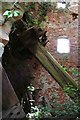
Inside the windmill
A peek through the window of the disused windmill at Threapwood, showing the huge wooden cog and vertical shaft of the old workings.
Image: © Dave Dunford
Taken: 5 Apr 2009
0.09 miles
5
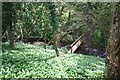
Footbridge below Threapwood windmill
A slightly odd and little-used footpath, which crosses a private garden (and compost heap!), gives access from the north to this pretty spot, where a footbridge crosses a stream. The leaves carpeting the ground are Ramsons or Wild Garlic.
Image: © Dave Dunford
Taken: 5 Apr 2009
0.12 miles
6
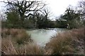
Pond, Lower Threapwood
Pond at the junctions of footpaths Oldcastle 17 and 18 near Lower Threapwood.
Image: © Dave Dunford
Taken: 5 Apr 2009
0.14 miles
7
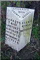
Old Milepost in Threapwood
Cast iron post by the UC road, in parish of Threapwood (Chester District), South of Upper Wood Farm, on the verge, on West side of road. Cast iron CCC1898, erected by the County Council in the 19th century.
Inscription reads:-
: FARNDON / 7 MILES / CHURTON 7¾ / ALDFORD 9½ / CHESTER 15 / WORTHENBURY 2 / MALPAS 4 : : CHESHIRE / 1898 / COUNTY COUNCIL : : HANMER / 4½ MILES / WHITCHURCH 8½ :
Milestone Society National ID: CH_FDWC07
Image: © JV Nicholls & J Higgins
Taken: 20 Oct 2003
0.18 miles
8
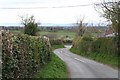
Sarn Bank Road
With distant views to the Welsh hills beyond Wrexham. The T-junction at the end of the lane is just visible.
Image: © Dave Dunford
Taken: 5 Apr 2009
0.21 miles
9
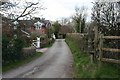
Lower Threapwood
From the drive to The Greaves. Another footpath heads right here.
Image: © Dave Dunford
Taken: 5 Apr 2009
0.25 miles