IMAGES TAKEN NEAR TO
Cuddington, MALPAS, SY14 7AJ
Introduction
This page details the photographs taken nearby to SY14 7AJ by members of the Geograph project.
The Geograph project started in 2005 with the aim of publishing, organising and preserving representative images for every square kilometre of Great Britain, Ireland and the Isle of Man.

There are currently over 7.5m images from over14,400 individuals and you can help contribute to the project by visiting https://www.geograph.org.uk
Image Map (Loading...)


Getting Data...Please wait
Leaflet Map data © OpenStreetMap
Images are licensed for reuse under creativecommons.org/licenses/by-sa/2.0
Notes
- Clicking on the map will re-center to the selected point.
- The higher the marker number, the further away the image location is from the centre of the postcode.
Image Listing (2 Images Found)
Images are licensed for reuse under creativecommons.org/licenses/by-sa/2.0
Image
Details
Distance
1
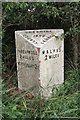
Old Milepost by the B5069 at Cuddington Green
Cast iron post by the B5069, in parish of Cuddington (Vale Royal District), West of Ashley Court, in hedge, on South side of road. Cast iron CCC1898, erected by the County Council in the 19th century.
Inscription reads:-
: THREAPWOOD / 2 MILES / WORTHENBURY 2½ : : CHESHIRE / 1898 / COUNTY COUNCIL : : MALPAS / 2 MILES :
Maker:-
: W H SMITH & CO / MAKERS / WHITCHURCH :
Milestone Society National ID: CH_MPTP02
Image: © JV Nicholls & J Higgins
Taken: 20 Oct 2003
0.12 miles
2
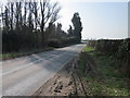
B5069 (Wrexham Road) at Cuddington Heath
The B5069 (Wrexham Road) heading west away from Cuddington Heath towards Upper Threapwood.
Image: © Jeff Buck
Taken: 19 Mar 2015
0.25 miles