IMAGES TAKEN NEAR TO
Barkstone Drive, SHREWSBURY, SY1 3XT
Introduction
This page details the photographs taken nearby to Barkstone Drive, SY1 3XT by members of the Geograph project.
The Geograph project started in 2005 with the aim of publishing, organising and preserving representative images for every square kilometre of Great Britain, Ireland and the Isle of Man.

There are currently over 7.5m images from over14,400 individuals and you can help contribute to the project by visiting https://www.geograph.org.uk
Image Map
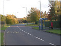
Images are licensed for reuse under creativecommons.org/licenses/by-sa/2.0
Notes
- Clicking on the map will re-center to the selected point.
- The higher the marker number, the further away the image location is from the centre of the postcode.
Image Listing (23 Images Found)
Images are licensed for reuse under creativecommons.org/licenses/by-sa/2.0
Image
Details
Distance
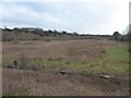
2
Old River Bed, Shrewsbury
This view shows the former bed of the River Severn in Shrewsbury, the current route of the Severn being about a mile from this point.
Image: © Andrew Bennett
Taken: 24 Apr 2007
0.10 miles
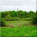
3
Part of the Bagley Brook, the old course of the River Severn on the outskirts of Shrewsbury
I would dearly love to explore across this area, but today I have a walk to complete.
Image: © Jeremy Bolwell
Taken: 3 Jan 2021
0.10 miles
4
Hubert Way
Hubert Way, looking towards its junction with Ellesmere Road (A528)
The junction on the left is Butterwick Drive.
This area is also known as Herongate.
Image: © Andrew Bennett
Taken: 24 Apr 2007
0.12 miles
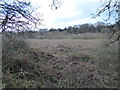
5
The old course of the River Severn at Bagley Brook, Shrewsbury
Now an SSSI and a very interesting landscape.
Image: © Jeremy Bolwell
Taken: 3 Jan 2021
0.13 miles
6
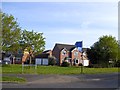
Modern houses off Hubert Way, Shrewsbury
The houses are in Broadhaven Close. Hubert Way serves as the boundary road for the whole housing estate
Image: © David Smith
Taken: 23 Apr 2015
0.13 miles
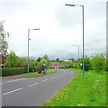
7
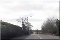
Entering Mount Pleasant on Ellesmere Road
Image: © John Firth
Taken: 13 Apr 2014
0.13 miles
8
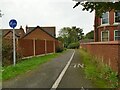
Cyle path off Ellesmere Road
Part of a network of suburban cycle paths funded by Sustrans' 'Connect2' scheme and constructed between 2008 and 2013.
Image: © Stephen Craven
Taken: 16 Oct 2022
0.14 miles
9
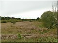
Old River Bed SSSI
This 18 hectare nature reserve occupies part of the former bed of the River Severn, which has been cut off from the main course of the river since the last glaciation.
Image: © Stephen Craven
Taken: 16 Oct 2022
0.14 miles
10
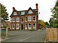
The Moveage, Ellesmere Road
Old maps do show a large of that name on a nearby site. Grace's Guide online shows it was occupied in 1917 by G. Woodvine, Engineer. But it's not the present structure. The grounds have been used to develop social housing.
Image: © Stephen Craven
Taken: 16 Oct 2022
0.15 miles