IMAGES TAKEN NEAR TO
Cartmel Drive, SHREWSBURY, SY1 3TB
Introduction
This page details the photographs taken nearby to Cartmel Drive, SY1 3TB by members of the Geograph project.
The Geograph project started in 2005 with the aim of publishing, organising and preserving representative images for every square kilometre of Great Britain, Ireland and the Isle of Man.

There are currently over 7.5m images from over14,400 individuals and you can help contribute to the project by visiting https://www.geograph.org.uk
Image Map
Images are licensed for reuse under creativecommons.org/licenses/by-sa/2.0
Notes
- Clicking on the map will re-center to the selected point.
- The higher the marker number, the further away the image location is from the centre of the postcode.
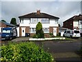
Image Listing (21 Images Found)
Images are licensed for reuse under creativecommons.org/licenses/by-sa/2.0
Image
Details
Distance
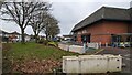
1
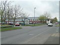
Charlie's Store
Shopping area in Harlescott Shrewsbury
Image: © Andy and Hilary
Taken: 15 Apr 2005
0.11 miles
6
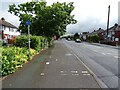
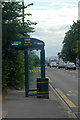
Dual use path beside Whitchurch Road (A5112)
Image: © JThomas
Taken: 3 Jul 2024
0.17 miles

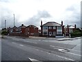
9
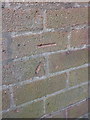
OS benchmark - Shrewsbury, no 77 Lancaster Road
An OS cutmark on the wall of no 77 Lancaster Road; originally levelled at 68.966m above Ordnance Datum Newlyn.
Image: © Richard Law
Taken: 17 Jun 2014
0.20 miles