IMAGES TAKEN NEAR TO
Lancaster Road, SHREWSBURY, SY1 3JG
Introduction
This page details the photographs taken nearby to Lancaster Road, SY1 3JG by members of the Geograph project.
The Geograph project started in 2005 with the aim of publishing, organising and preserving representative images for every square kilometre of Great Britain, Ireland and the Isle of Man.

There are currently over 7.5m images from over14,400 individuals and you can help contribute to the project by visiting https://www.geograph.org.uk
Image Map
Images are licensed for reuse under creativecommons.org/licenses/by-sa/2.0
Notes
- Clicking on the map will re-center to the selected point.
- The higher the marker number, the further away the image location is from the centre of the postcode.
Image Listing (20 Images Found)
Images are licensed for reuse under creativecommons.org/licenses/by-sa/2.0
Image
Details
Distance
1

OS benchmark - Shrewsbury, no 25 Lancaster Road
An OS cutmark on the side wall of the (now-converted) garage of no 25 Lancaster Road; originally levelled at 68.039m above Ordnance Datum Newlyn.
Image: © Richard Law
Taken: 17 Jun 2014
0.02 miles
2
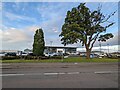
Mature oak in front of Volkswagen dealership
A mature, but stressed looking, oak in front of a Volkswagen car dealership in Harlescott.
Image: © TCExplorer
Taken: 5 Oct 2023
0.09 miles
3
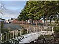
Former Stadco factory, Shrewsbury
Built in the early 1950s, this building has been unused for a decade or so and was formerly utilised by Stadco (Shrewsbury Tool and Die Company). Plans were submitted almost a decade ago to demolish the building, which is not listed, but these have not come to pass, and presumably has now expired. There are plans to fell almost all of the trees in front of the building.
Image: © TCExplorer
Taken: 5 Oct 2023
0.11 miles
4
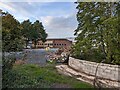
Former Stadco factory, Shrewsbury
Built in the early 1950s, this building has been unused for a decade or so and was formerly utilised by Stadco (Shrewsbury Tool and Die Company). Plans were submitted almost a decade ago to demolish the building, which is not listed, but these have not come to pass, and presumably has now expired. There are plans to fell almost all of the trees in front of the building.
Image: © TCExplorer
Taken: 5 Oct 2023
0.11 miles
5
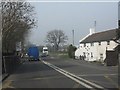
Cottages beside Harlescott level crossing
Now surrounded by modern warehousing and retail parks.
Image: © Peter Whatley
Taken: 23 Mar 2012
0.13 miles
6
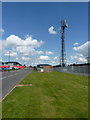
Telecoms mast on Vanguard Way, Harlescott
Image: © Richard Law
Taken: 17 May 2010
0.13 miles
7
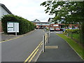
The Longbow Professional Centre
A small business and office park off Harlescott Lane in north Shrewsbury.
Image: © Richard Law
Taken: 17 Jun 2014
0.14 miles
8
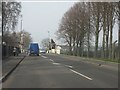
Harlescott Lane at the level crossing
The railway is that between Crewe and Shrewsbury.
Image: © Peter Whatley
Taken: 23 Mar 2012
0.15 miles
9
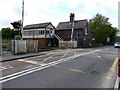
Harlescott Crossing
The main line north out of Shrewsbury towards Wem, Whitchurch & Crewe crosses Harlescott Lane
Image: © Richard Law
Taken: 17 May 2010
0.15 miles