IMAGES TAKEN NEAR TO
Westbury Road, SHREWSBURY, SY1 3HG
Introduction
This page details the photographs taken nearby to Westbury Road, SY1 3HG by members of the Geograph project.
The Geograph project started in 2005 with the aim of publishing, organising and preserving representative images for every square kilometre of Great Britain, Ireland and the Isle of Man.

There are currently over 7.5m images from over14,400 individuals and you can help contribute to the project by visiting https://www.geograph.org.uk
Image Map
Images are licensed for reuse under creativecommons.org/licenses/by-sa/2.0
Notes
- Clicking on the map will re-center to the selected point.
- The higher the marker number, the further away the image location is from the centre of the postcode.
Image Listing (20 Images Found)
Images are licensed for reuse under creativecommons.org/licenses/by-sa/2.0
Image
Details
Distance
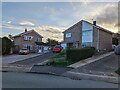
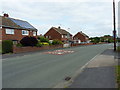
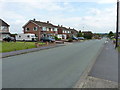
4
Looking south along Boscobel Drive, Shrewsbury
Image: © TCExplorer
Taken: 5 Oct 2023
0.12 miles
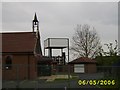
5
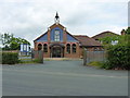
The Emmanuel Church
On Mount Pleasant Road, this is the local United Anglican Methodist Church.
Image: © Richard Law
Taken: 17 Jun 2014
0.13 miles
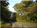
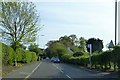
6
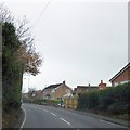
Ellesmere Road, passing houses in Harlescott
Ellesmere Road (A528) is a boundary between farmland and housing on the north of Shrewsbury. To the right are several estates, to the left, farms.
Image: © David Smith
Taken: 28 Nov 2014
0.14 miles
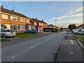
7
Southwards along Mount Pleasant Road
Looking in the general direction of Shrewsbury town centre.
Image: © Richard Law
Taken: 17 Jun 2014
0.14 miles
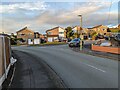
8
Bus stop on Ellesmere Road, Shrewsbury
On the northern edge of Shrewsbury, this stop serves the housing estates behind the hedge on the left. There is pedestrian access through the hedge by the small barrier opposite the leading car
Image: © David Smith
Taken: 23 Apr 2015
0.15 miles