IMAGES TAKEN NEAR TO
Edgeley Road, WHITCHURCH, SY13 4NJ
Introduction
This page details the photographs taken nearby to Edgeley Road, SY13 4NJ by members of the Geograph project.
The Geograph project started in 2005 with the aim of publishing, organising and preserving representative images for every square kilometre of Great Britain, Ireland and the Isle of Man.

There are currently over 7.5m images from over14,400 individuals and you can help contribute to the project by visiting https://www.geograph.org.uk
Image Map
Images are licensed for reuse under creativecommons.org/licenses/by-sa/2.0
Notes
- Clicking on the map will re-center to the selected point.
- The higher the marker number, the further away the image location is from the centre of the postcode.
Image Listing (13 Images Found)
Images are licensed for reuse under creativecommons.org/licenses/by-sa/2.0
Image
Details
Distance
1
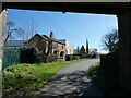
Under the railway bridge
Once the edge of town I assume, but now cluttered with newish industrial units.
Image: © Jeremy Bolwell
Taken: 4 Apr 2023
0.02 miles
2
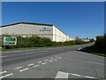
Large warehouses on the outskirts of Whitchurch
Americold. They do temperature controlled warehouses. They do them big.
Image: © Jeremy Bolwell
Taken: 4 Apr 2023
0.11 miles
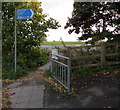
4
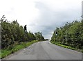
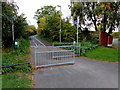
Rural part of Edgeley Road, Whitchurch
Old maps show that Edgeley Road used to be a through road ahead. Now it is severed by the A525, about 400 metres ahead. Near the A525, metal barriers across Edgeley Road block the passage of motor vehicles, but not walkers and cyclists.
Image: © Jaggery
Taken: 22 Oct 2015
0.15 miles
5
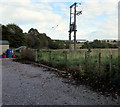
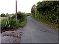
Rural electricity substation at the SE edge of Whitchurch
On the north side of Edgeley Road.
Image: © Jaggery
Taken: 22 Oct 2015
0.17 miles
6
Whitchurch to Oswestry railway trackbed
View south west towards Fenn's bank and Oswestry. The line closed in 1965 and is now a path and cycleway.
Image: © Nigel Thompson
Taken: 24 Nov 2015
0.20 miles
7
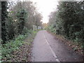
Hatton Way towards Whitchurch railway station
Heading away from Edgeley Road, the combined footpath & cycleway follows the route of a dismantled railway.
Image: © Jaggery
Taken: 22 Oct 2015
0.22 miles
8
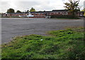
Whitchurch Rugby Club buildings
Viewed from Edgeley Road in the SE of Whitchurch (Shropshire).
Image: © Jaggery
Taken: 22 Oct 2015
0.22 miles
9
Hatton Way direction sign, Edgeley Road, Whitchurch
The sign shows Shrewsbury Oswestry Ellesmere and National Cycle Network routes 31 and 45.
Image: © Jaggery
Taken: 22 Oct 2015
0.23 miles
10
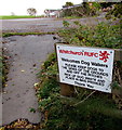
Whitchurch RUFC welcomes dog walkers, Whitchurch
The notice facing Edgeley Road gives instructions to dog walkers.
RUFC = Rugby Union Football Club.
Image: © Jaggery
Taken: 22 Oct 2015
0.23 miles