IMAGES TAKEN NEAR TO
Hollyhurst, Marbury, WHITCHURCH, SY13 4LZ
Introduction
This page details the photographs taken nearby to SY13 4LZ by members of the Geograph project.
The Geograph project started in 2005 with the aim of publishing, organising and preserving representative images for every square kilometre of Great Britain, Ireland and the Isle of Man.

There are currently over 7.5m images from over14,400 individuals and you can help contribute to the project by visiting https://www.geograph.org.uk
Image Map
Images are licensed for reuse under creativecommons.org/licenses/by-sa/2.0
Notes
- Clicking on the map will re-center to the selected point.
- The higher the marker number, the further away the image location is from the centre of the postcode.
Image Listing (4 Images Found)
Images are licensed for reuse under creativecommons.org/licenses/by-sa/2.0
Image
Details
Distance
1
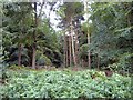
Hollyhurst Wood, Whitchurch
Whitchurch Urban. Hollyhurst Wood from the Cheshire/Shropshire county boundary on Ossmere Lane.
Image: © Mike Harris
Taken: 2 Aug 2006
0.07 miles
2
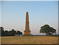
Obelisk, Combermere Park
Obelisk, dated 1890, at the edge of Combermere Park. It commemorates Stapleton Cotton, 1st Viscount Combermere.
Image: © Espresso Addict
Taken: 9 Jun 2006
0.13 miles
3
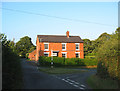
House at Hollyhurst junction
A brick house with a large barn stands at the junction of the minor roads to Whitchurch (right) and Marbury. The left wall of the house (on the Marbury road) has a wall-mounted postbox inscribed GR
Image: © Espresso Addict
Taken: 7 Aug 2006
0.15 miles
4
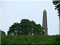
Monument at Hollyhurst
A monument on top of a small hill at Hollyhurst
Image: © Nigel Williams
Taken: 5 Jun 2006
0.18 miles