IMAGES TAKEN NEAR TO
Black Park, WHITCHURCH, SY13 4JR
Introduction
This page details the photographs taken nearby to SY13 4JR by members of the Geograph project.
The Geograph project started in 2005 with the aim of publishing, organising and preserving representative images for every square kilometre of Great Britain, Ireland and the Isle of Man.

There are currently over 7.5m images from over14,400 individuals and you can help contribute to the project by visiting https://www.geograph.org.uk
Image Map
Images are licensed for reuse under creativecommons.org/licenses/by-sa/2.0
Notes
- Clicking on the map will re-center to the selected point.
- The higher the marker number, the further away the image location is from the centre of the postcode.
Image Listing (3 Images Found)
Images are licensed for reuse under creativecommons.org/licenses/by-sa/2.0
Image
Details
Distance
1
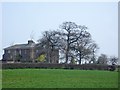
The Lodge, Black Park
SJ 5639 4297 @ 120° - The Lodge, Black Park (Whitchurch) from Black Park Road.
Image: © Mike Harris
Taken: 1 Apr 2007
0.17 miles
2
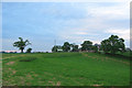
Black Park Lodge at sundown
The Lodge, Black Park stands on a low hill surrounded by cattle pasture. The footpath on the left stops in another hundred metres
Image: © Espresso Addict
Taken: 16 Jun 2006
0.22 miles
3
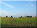
Young maize, by Oss Mere
Undulating farmland immediately south of Ossmere Wood. The farm on the horizon is Black Park Lodge
Image: © Espresso Addict
Taken: 16 Jun 2006
0.23 miles