IMAGES TAKEN NEAR TO
The Meadows, WHITCHURCH, SY13 4EU
Introduction
This page details the photographs taken nearby to The Meadows, SY13 4EU by members of the Geograph project.
The Geograph project started in 2005 with the aim of publishing, organising and preserving representative images for every square kilometre of Great Britain, Ireland and the Isle of Man.

There are currently over 7.5m images from over14,400 individuals and you can help contribute to the project by visiting https://www.geograph.org.uk
Image Map (Loading...)


Getting Data...Please wait
Leaflet Map data © OpenStreetMap
Images are licensed for reuse under creativecommons.org/licenses/by-sa/2.0
Notes
- Clicking on the map will re-center to the selected point.
- The higher the marker number, the further away the image location is from the centre of the postcode.
Image Listing (7 Images Found)
Images are licensed for reuse under creativecommons.org/licenses/by-sa/2.0
Image
Details
Distance
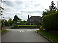
1
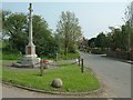
War Memorial
Ash Village War Memorial.
Image: © Andy and Hilary
Taken: 24 Apr 2005
0.02 miles
2
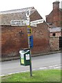
Old Direction Sign - Signpost in Ash Parva, Whitchurch parish
Annulus finial - 3 arms; Shropshire CC halo by the UC road, in parish of Whitchurch Rural (North Shropshire District), Ash Parva.
Surveyed
Milestone Society National ID: SA_SJ5739
Image: © Milestone Society
Taken: Unknown
0.05 miles
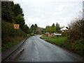
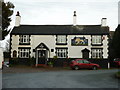
7
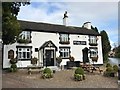
The White Lion
A community-owned pub in Ash Magna.
Image: © John H Darch
Taken: 4 Oct 2019
0.22 miles