IMAGES TAKEN NEAR TO
New Woodhouses, WHITCHURCH, SY13 4ER
Introduction
This page details the photographs taken nearby to New Woodhouses, SY13 4ER by members of the Geograph project.
The Geograph project started in 2005 with the aim of publishing, organising and preserving representative images for every square kilometre of Great Britain, Ireland and the Isle of Man.

There are currently over 7.5m images from over14,400 individuals and you can help contribute to the project by visiting https://www.geograph.org.uk
Image Map
Images are licensed for reuse under creativecommons.org/licenses/by-sa/2.0
Notes
- Clicking on the map will re-center to the selected point.
- The higher the marker number, the further away the image location is from the centre of the postcode.
Image Listing (2 Images Found)
Images are licensed for reuse under creativecommons.org/licenses/by-sa/2.0
Image
Details
Distance
1
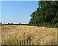
Barley field by Long Wood
The eastern boundary of the narrow strip of mixed woodland, Long Wood, which conceals an unnamed brook. View looking north, from by the track to New Farm
Image: © Espresso Addict
Taken: 30 Jun 2006
0.15 miles
2
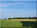
Long Wood across the fields
View eastwards from the lane towards Long Wood. The distant field is barley
Image: © Espresso Addict
Taken: 30 Jun 2006
0.15 miles