IMAGES TAKEN NEAR TO
Pemberton Close, WHITCHURCH, SY13 4BF
Introduction
This page details the photographs taken nearby to Pemberton Close, SY13 4BF by members of the Geograph project.
The Geograph project started in 2005 with the aim of publishing, organising and preserving representative images for every square kilometre of Great Britain, Ireland and the Isle of Man.

There are currently over 7.5m images from over14,400 individuals and you can help contribute to the project by visiting https://www.geograph.org.uk
Image Map (Loading...)


Getting Data...Please wait
Leaflet Map data © OpenStreetMap
Images are licensed for reuse under creativecommons.org/licenses/by-sa/2.0
Notes
- Clicking on the map will re-center to the selected point.
- The higher the marker number, the further away the image location is from the centre of the postcode.
Image Listing (17 Images Found)
Images are licensed for reuse under creativecommons.org/licenses/by-sa/2.0
Image
Details
Distance
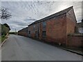
2
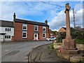
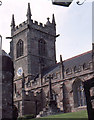
Ightfield Church
Heaven in the Countryside.
Image: © Andy and Hilary
Taken: 24 Apr 2005
0.08 miles
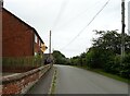
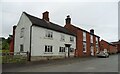
3
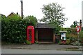
K6 telephone box and bus shelter on Burleydam Road, Ightfield
Image: © JThomas
Taken: 3 Jul 2024
0.10 miles
5
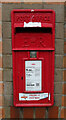
Elizabeth II postbox on Burleydam Road, Ightfield
Postbox No. SY13 693.
Image: © JThomas
Taken: 3 Jul 2024
0.10 miles
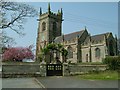
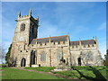
8
Ightfield: the church from the churchyard gate
Image: © Christopher Hilton
Taken: 31 May 1990
0.11 miles
9
Ightfield, Shropshire, St John the Baptist
Image: © Dave Kelly
Taken: 10 Jan 2018
0.11 miles