IMAGES TAKEN NEAR TO
Coton, WHITCHURCH, SY13 3LQ
Introduction
This page details the photographs taken nearby to SY13 3LQ by members of the Geograph project.
The Geograph project started in 2005 with the aim of publishing, organising and preserving representative images for every square kilometre of Great Britain, Ireland and the Isle of Man.

There are currently over 7.5m images from over14,400 individuals and you can help contribute to the project by visiting https://www.geograph.org.uk
Image Map (Loading...)


Getting Data...Please wait
Leaflet Map data © OpenStreetMap
Images are licensed for reuse under creativecommons.org/licenses/by-sa/2.0
Notes
- Clicking on the map will re-center to the selected point.
- The higher the marker number, the further away the image location is from the centre of the postcode.
Image Listing (5 Images Found)
Images are licensed for reuse under creativecommons.org/licenses/by-sa/2.0
Image
Details
Distance
2
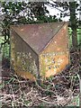
Old Milepost by the B5476, Coton, Whixall parish
Cast iron post by the B5476, in parish of Whixall (North Shropshire District), Coton, near cottage No. 4, under hedge on verge, on East side of road. Salop iron T-post, erected by the County Council in the 19th/20th century.
Inscription reads:-
: WEM / 5 / MILES : : WHITCHURCH / 4 / MILES :
Grade II listed.
List Entry Number: 1236506 https://historicengland.org.uk/listing/the-list/list-entry/1236506
Milestone Society National ID: SA_WCWM04
Image: © J Haynes
Taken: 3 Nov 2011
0.13 miles
4
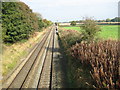
Straight tracks in Shropshire
Tracks running north from bridge near Mill Farm
Image: © Peter Fleming
Taken: 19 Oct 2007
0.15 miles
