IMAGES TAKEN NEAR TO
Church Close, WHITCHURCH, SY13 3JH
Introduction
This page details the photographs taken nearby to Church Close, SY13 3JH by members of the Geograph project.
The Geograph project started in 2005 with the aim of publishing, organising and preserving representative images for every square kilometre of Great Britain, Ireland and the Isle of Man.

There are currently over 7.5m images from over14,400 individuals and you can help contribute to the project by visiting https://www.geograph.org.uk
Image Map
Images are licensed for reuse under creativecommons.org/licenses/by-sa/2.0
Notes
- Clicking on the map will re-center to the selected point.
- The higher the marker number, the further away the image location is from the centre of the postcode.
Image Listing (12 Images Found)
Images are licensed for reuse under creativecommons.org/licenses/by-sa/2.0
Image
Details
Distance
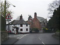
1
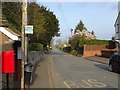
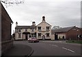
Bus stop, Tilstock
The road passes the church on the way towards the A41/A49.
Image: © Richard Webb
Taken: 30 Mar 2019
0.04 miles
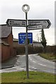
2
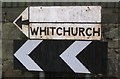
Old and new roadsigns
The panel above the name 'Whitchurch' has been left blank. There is no evidence that there has ever been raised lettering on it.
Image: © Ceri Thomas
Taken: 28 Dec 2010
0.06 miles
3
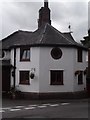
Old Toll House by the B5476, Tilstock
The Round House on the B5476 in Tilstock.
To be surveyed
Milestone Society National ID: SA.WHR
Image: © Milestone Society
Taken: Unknown
0.06 miles
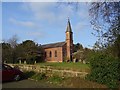
4
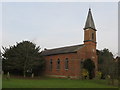
Christ Church at Tilstock
Viewed from the south-west.
Image: © Peter Wood
Taken: 5 Dec 2016
0.06 miles
6
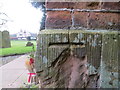
Ordnance Survey Cut Mark
This mark can be found on the wall of Christ Church at Tilstock.
For more detail see : http://www.bench-marks.org.uk/bm81055
Image: © Peter Wood
Taken: 5 Dec 2016
0.07 miles

9
Old Direction Sign - Signpost by the B5476, Tilstock
Annulus finial - 3 Worboys arms; Shropshire CC modern halo by the B5476, in parish of Whitchurch Rural (North Shropshire District), Tilstock, junction with Maltkiln Lane.
Surveyed
Milestone Society National ID: SA_SJ5437
Image: © Milestone Society
Taken: Unknown
0.09 miles