IMAGES TAKEN NEAR TO
Ellesmere Road, WHITCHURCH, SY13 3HD
Introduction
This page details the photographs taken nearby to Ellesmere Road, SY13 3HD by members of the Geograph project.
The Geograph project started in 2005 with the aim of publishing, organising and preserving representative images for every square kilometre of Great Britain, Ireland and the Isle of Man.

There are currently over 7.5m images from over14,400 individuals and you can help contribute to the project by visiting https://www.geograph.org.uk
Image Map
Images are licensed for reuse under creativecommons.org/licenses/by-sa/2.0
Notes
- Clicking on the map will re-center to the selected point.
- The higher the marker number, the further away the image location is from the centre of the postcode.
Image Listing (5 Images Found)
Images are licensed for reuse under creativecommons.org/licenses/by-sa/2.0
Image
Details
Distance
2
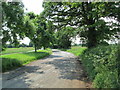
Lay-by near Bronington
This pleasant parking area was probably once part of the main road, which is now just to the left.
Image: © David Weston
Taken: 5 Jul 2013
0.13 miles
3
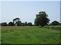
Field near Bronington
Looking north-west, from a lay-by on the A495 near Bronington.
Image: © David Weston
Taken: 5 Jul 2013
0.15 miles
5
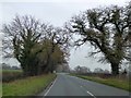
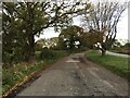
A495 east of Bronington
At the bend ahead, there is a lay-by, formed when the road was realigned. The trees on the left continue around the lay-by, as a further reminder of the former route of the main road
Image: © David Smith
Taken: 28 Nov 2014
0.20 miles