IMAGES TAKEN NEAR TO
Conery Lane, WHITCHURCH, SY13 3HA
Introduction
This page details the photographs taken nearby to Conery Lane, SY13 3HA by members of the Geograph project.
The Geograph project started in 2005 with the aim of publishing, organising and preserving representative images for every square kilometre of Great Britain, Ireland and the Isle of Man.

There are currently over 7.5m images from over14,400 individuals and you can help contribute to the project by visiting https://www.geograph.org.uk
Image Map
Images are licensed for reuse under creativecommons.org/licenses/by-sa/2.0
Notes
- Clicking on the map will re-center to the selected point.
- The higher the marker number, the further away the image location is from the centre of the postcode.
Image Listing (4 Images Found)
Images are licensed for reuse under creativecommons.org/licenses/by-sa/2.0
Image
Details
Distance
1
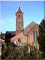
Bronington Church
The parish church was originally a brick-built barn and which was converted to a church in 1836. It was further improved and extended in 1863, and was consecrated on 22 November 1863.
Image: © John Harding
Taken: 22 Aug 2006
0.16 miles
2
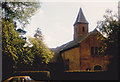
Holy Trinity, Bronington
A converted and extended barn.
Image: © Jonathan Thacker
Taken: 25 Oct 1986
0.22 miles
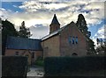
4
Holy Trinity church, Bronington
Converted in the C19 out of a large barn, the church still feels a little agricultural, which seems highly fitting here.
Image: © Mike Parker
Taken: 17 Mar 2022
0.23 miles