IMAGES TAKEN NEAR TO
Moss Lane, WHITCHURCH, SY13 2RY
Introduction
This page details the photographs taken nearby to Moss Lane, SY13 2RY by members of the Geograph project.
The Geograph project started in 2005 with the aim of publishing, organising and preserving representative images for every square kilometre of Great Britain, Ireland and the Isle of Man.

There are currently over 7.5m images from over14,400 individuals and you can help contribute to the project by visiting https://www.geograph.org.uk
Image Map (Loading...)


Getting Data...Please wait
Leaflet Map data © OpenStreetMap
Images are licensed for reuse under creativecommons.org/licenses/by-sa/2.0
Notes
- Clicking on the map will re-center to the selected point.
- The higher the marker number, the further away the image location is from the centre of the postcode.
Image Listing (18 Images Found)
Images are licensed for reuse under creativecommons.org/licenses/by-sa/2.0
Image
Details
Distance
1
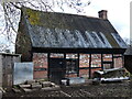
Old building on Moss Lane near Whixall
Traditional old cottage now being used for storage - what a structure!
Image: © Andrew Shannon
Taken: 13 Apr 2023
0.03 miles
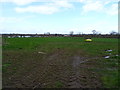
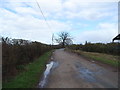
4
Drained farmland between Moss Lane and Fields Farm
Looking south from the Llangollen Canal. The shed on the horizon is at Rye Hills Farm.
Image: © Christine Johnstone
Taken: 17 Sep 2016
0.15 miles
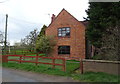
5
Minor road near Rye Hill Farm
Looking north east.
Image: © JThomas
Taken: 14 Mar 2019
0.18 miles
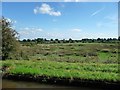
6
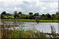
Flooded land west of Whixall, Shropshire
South of and seen from the Llangollen Canal.
Image: © Roger D Kidd
Taken: 22 Sep 2015
0.20 miles
7
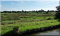
Rough grassland, south of Whixall Moss
On the south bank of the Llangollen Canal. The vehicles are parked on Moss Lane.
Image: © Christine Johnstone
Taken: 17 Sep 2016
0.21 miles
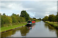
8
Llangollen Canal - Morris's Lift Bridge
Heading west
Image: © Pierre Terre
Taken: 21 May 2005
0.23 miles
9
Llangollen Canal north-west of Whixall in Shropshire
Looking north-east towards Hollinwood.
The Llangollen Branch of the Shropshire Union Canal starts by the River Dee at Llantysilio and leads to the main line at Hurleston Junction, a distance of 46 miles, with twenty-one locks. Water is supplied from the River Dee to the canal, and on to Hurleston Reservoir, a source of domestic water supplies.
Image: © Roger D Kidd
Taken: 22 Sep 2015
0.24 miles
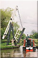
10
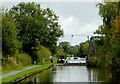
Morris Lift Bridge near Whixall in Shropshire
A telephoto assisted image looking at Morris Lift Bridge which is No 45 across the Llangollen Canal. It is a farmer's accommodation bridge linking Moss Lane to a farm and a scrapyard north of the canal. The bridge is about to be raised to allow boats passage in both directions.
See also:
Image]
Image]
Image]
Image: © Roger D Kidd
Taken: 22 Sep 2015
0.24 miles