IMAGES TAKEN NEAR TO
Bettisfield, WHITCHURCH, SY13 2JZ
Introduction
This page details the photographs taken nearby to SY13 2JZ by members of the Geograph project.
The Geograph project started in 2005 with the aim of publishing, organising and preserving representative images for every square kilometre of Great Britain, Ireland and the Isle of Man.

There are currently over 7.5m images from over14,400 individuals and you can help contribute to the project by visiting https://www.geograph.org.uk
Image Map
Images are licensed for reuse under creativecommons.org/licenses/by-sa/2.0
Notes
- Clicking on the map will re-center to the selected point.
- The higher the marker number, the further away the image location is from the centre of the postcode.
Image Listing (7 Images Found)
Images are licensed for reuse under creativecommons.org/licenses/by-sa/2.0
Image
Details
Distance
1
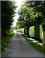
Well kept.
This finely-manicured driveway led to Bettisfield Park.
Image: © Geoff Evans
Taken: 5 Aug 2007
0.07 miles
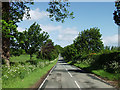
2
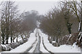
New Road in Winter
Photograph taken looking towards Hanmer in a position adjacent to Beech Tree Cottage. March 2006.
Image: © John Harding
Taken: 12 Mar 2006
0.14 miles
3
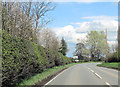
New Lane junction with A495
From eastbound A495
Image: © John Firth
Taken: 14 Apr 2012
0.18 miles
5

Sky on fire
December sunset north of the A495.
Image: © John H Darch
Taken: 7 Dec 2020
0.19 miles
6
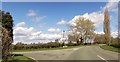
New Road
Looking in the direction of Hanmer. Photograph taken adjacent to Beech Tree Cottage. Spring 2003.
Image: © John Harding
Taken: 25 May 2002
0.20 miles
7
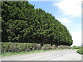
Edge of the Rookery
A plantation on the Bettisfield Hall estate.
Image: © John H Darch
Taken: 22 Apr 2020
0.24 miles