IMAGES TAKEN NEAR TO
The Chequer, WHITCHURCH, SY13 2JQ
Introduction
This page details the photographs taken nearby to The Chequer, SY13 2JQ by members of the Geograph project.
The Geograph project started in 2005 with the aim of publishing, organising and preserving representative images for every square kilometre of Great Britain, Ireland and the Isle of Man.

There are currently over 7.5m images from over14,400 individuals and you can help contribute to the project by visiting https://www.geograph.org.uk
Image Map (Loading...)


Getting Data...Please wait
Leaflet Map data © OpenStreetMap
Images are licensed for reuse under creativecommons.org/licenses/by-sa/2.0
Notes
- Clicking on the map will re-center to the selected point.
- The higher the marker number, the further away the image location is from the centre of the postcode.
Image Listing (7 Images Found)
Images are licensed for reuse under creativecommons.org/licenses/by-sa/2.0
Image
Details
Distance
2
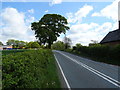
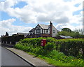
The road to Whitewell
Looking back towards the A525 on the road to Whitewell, with the walls of Broad Oak Farm on the right.
Image: © Eirian Evans
Taken: 19 Jun 2006
0.19 miles
3
Elizabeth II postbox on the A525, The Chequer
Postbox No. SY13 642.
See Image] for close up.
Image: © JThomas
Taken: 4 May 2019
0.21 miles
4
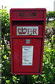
Close up, Elizabeth II postbox on the A525, The Chequer
Postbox No. SY13 642.
See Image] for context.
Image: © JThomas
Taken: 4 May 2019
0.21 miles
5
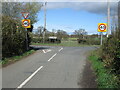
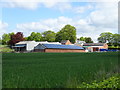
Junction: New Hall Lane joins the A525
Image: © John H Darch
Taken: 29 Mar 2021
0.21 miles